|
|
|
Floods and River Management
Rivers have always flooded and humans have always attempted to manage rivers. The ancient civilisations of Mesopatania and Egypt would build dykes and dams to hold back the waters following inundation. Indigenous skills, worldwide have created ingenious methods of interacting with rivers to increase food supply. Over time humans have modernised their engineering and in places have built vast structures to control and regulate the flow of rivers. We need not look any further than recent developments in China. The shear ambition of China's South-North Water Transfer Project dwarfs the remarkable achievement of the 3-Gorges Dam. However, major multi-purpose dam projects once common place in developed countries are now almost entirely part of the development strategies of developing countries and NICs, with India and China leading the way. In Europe and the US large scale river managment schemes have had mixed success and in many cases river management projects are reverting back to softer approaches in the realisation that the natural river system and catchment has much to offer. River management can be divided into hard and soft engineering. In both cases they attempt to reduce or regulate discharge in the river. Hard engineering is expensive, and tends to have a large impact on the river and the natural ecology and hydrology. Softer approaches tend to be more ecologically sensitive.
The Causes of Floods
Floods are a natural river process in response to changes in drainage basin inputs. They are an essential characteristic of the landscape and are fundamental to the development of floodplains, wetlands and many river features. Floods are therefore overwhelmingly caused by the physical environment. The interaction between atmospheric condition, drainage basin size, shape, geology and vegetation as well as the geometry of the channel varies over time and space. As a result, floods vary in magnitude and frequency. Human interaction, interference and management of the drainage basin and river channel have an influencing role as well. Large scale dams can control discharge and prevent floods. However, like in the failure of the Banqaio Resevoir Dam, in China,1975, where over 171000 people died and 11 million lost their homes, humans can be the direct cause of floods. With increased population and pressure on natural resources humans are having an increasingly important impact on the drainage basin. In many cases human impact is adding to or exacerbating both the frequency and magnitude of floods.
Physical Causes of Floods

Causes of Floods, FSC
The most important physical cause of floods concerns the interaction between precipitation and drainage basin response. The capacity of a river to cope with inputs becomes strained during both extended periods of rainfall (antecedent conditions) and short-term extreme rainfall events. e.g. Seathwaite, Cumbria, 2009, when 495mm of rain, the equivalent of several months of rainfall fell in just a 4 day period. In the case of the former, soils become saturated and the water table rises to the surface. As a result water cannot infiltrate and surface run-off occurs. For the latter, extreme rainfall leads to pooling on the surface and surface run-off. The nature of the drainage basin and its storage capacity is also and essential factor. Steep sided relief and/or impermeable rock and thin dense soils all accelerate surface run-off, which in turns leads to higher discharge and shorter lag times. Vegetation cover has an important role to play. Dense forest vegetation intercepts and transpires over 40% of precipitation inputs. Root networks further absorb water. The forest canopy intercepts rainfall slows inputs as throughfall. As a result surface run-off is minimalised and deep infiltration encouraged. Densely vegetated drainage basins therefore drastically reduce the magnitude and frequency of floods.
Human Causes of Floods
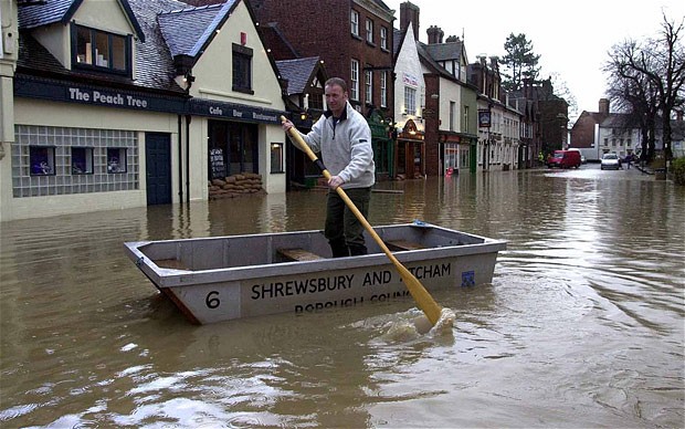
Source: The Telegraph
Human causes of flooding are a result of growing population pressure. Humans impact the interaction between precipitation and the drainage basin response through deforestation, as a result of agricultural development, floodplain drainage, urbanisation and channel management. Deforestation reduces the intercpetion and transpiration feedback resulting in increased quantities and rates of surface-run off. As a result more water reaches the river faster. In addition, deforestation exposes the soil to greater rates of erosion and nutrient leaching, which in turn increases the liklihood of further soil erosion and gullying. Soil erosion leads to sedimentation of the channel, which in turn reduces the capacity and hydraulic efficiency of the river, increasing the liklihood of floods. For example, deforestation in Nepal and Tibet is well known to be increasing the frequency and magnitude of floods in Bangladesh. Floodplain drainage, especially in more developed countries has created space for modern agricultural systems and urban infrastructure. In doing so, the natural storage capacity of the floodplain and the wetlands they support has been lost. During low frequency high magnitude floods, the water simply has no where else to go. The impacts of floods are also exacerbated by the very fact that settlements have been built on the floodplain. Urbanisation, which leads to the expansion of built-up, impermeable surface, such a roads, parking lots and shops mauls further increases the rates of run-off. The very design of settlement infrastructure is to transfer water as quickly possible to the river. This is achieved through road camber, building design, drainage and sub-surface infrastructure. The importance of mobility and the car further expands the reach of impermeable surfaces through the continued loss of front garden in favours paved drives. Due to the growing number of 2/3 car families, an area of vegetated garden equivalent to 21 times the size of Hyde Park was lost in London alone between 1998 and 2006. Read this Guardian article onlost London gardens. In addition, rivers capacity is often reduced in local sections of the river, in urban areas. At bridging points and contained sections, bottlenecks form that without additional spillways can quickly become flooded during high flow. In less developed countries, population pressure leads to increases in agriculture and urbanisation, which further increases the rates of soil erosion and sedimentation. In some cases, poor drainage can exacerbate flood events and in places where the river has been redirected and during extreme events the river simply takes its own route, regardless of what's its way. Finally, channel management of rivers has an impact on flooding. In most cases flood managment, such as dam construction and channelisation reduces the frequency of floods. However, with the main purpose of flood management aimed to increase capacity and move discharge as quickly and efficiently as possible past a settlement. The inevitable consequence is higher discharge and flood magnitude downstream. This is best illustrated in the Mississippi flood of 1993.
River Flood Case Studies - A fresh perspective
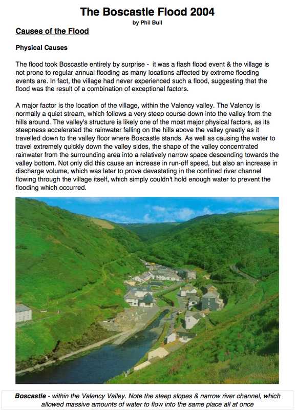
The Boscastle Flash Flood, 2004 - Click on the page to take you to outstanding PDF written by Phil Bull
The Pakistan Flood, 2010 - click on the page below to open the PDF
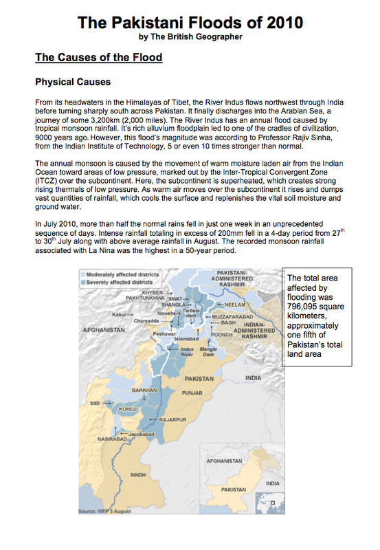
The Pakistan Flood 2010
Further Reading on the Pakistan floods of 2010 can be found in this Oxfam resource sheet
There are additional case study notes on Pakistan, provided here by Claire Ong
Here is a good detailed case study on the Mississippi floods of 1993
There are additional case study notes on Pakistan, provided here by Claire Ong
Here is a good detailed case study on the Mississippi floods of 1993
River Management
Hard Engineering
Multi-Purpose Dams
Multi-Purpose Dams are often built across the channel in order to store water and regulate the discharge of the river. Water is stored in a resevoir upstream of the dam and released in a controlled way. This protects the catchment downstream from potential flooding. Large dam projects are used for clean hydro-electric power, for large scale irrigation schemes and for strategies that open up the interior of countries for transport and trade. The downside of large-scale dams are the expensive costs; 3-Gorges was estimated to cost over $25 billion and despite its ability to produce 10% of the country's power requirements the environmental impacts on its ecology and river system are expected to be immense. Typical problems concern the disruption of migratory fish, sedimentaion and increased rates of erosion downstream. All this said, in the case of 3-Gorges, the number of people now free from the risk of flooding is the equivalent to the entire population of Belgium; 10 million. Multi-purpose dams therefore offer a country a means of regulating rivers at a vast scale and in doing so they protect the lives of many many people. Some disputed concerns with large scale-dams question their safety and sustainability, especially in regard to weight induced earthquakes and the acceleration of sedimentation due to landslides. Read this 3-Gorges Article from the BBC.
Multi-Purpose Dams are often built across the channel in order to store water and regulate the discharge of the river. Water is stored in a resevoir upstream of the dam and released in a controlled way. This protects the catchment downstream from potential flooding. Large dam projects are used for clean hydro-electric power, for large scale irrigation schemes and for strategies that open up the interior of countries for transport and trade. The downside of large-scale dams are the expensive costs; 3-Gorges was estimated to cost over $25 billion and despite its ability to produce 10% of the country's power requirements the environmental impacts on its ecology and river system are expected to be immense. Typical problems concern the disruption of migratory fish, sedimentaion and increased rates of erosion downstream. All this said, in the case of 3-Gorges, the number of people now free from the risk of flooding is the equivalent to the entire population of Belgium; 10 million. Multi-purpose dams therefore offer a country a means of regulating rivers at a vast scale and in doing so they protect the lives of many many people. Some disputed concerns with large scale-dams question their safety and sustainability, especially in regard to weight induced earthquakes and the acceleration of sedimentation due to landslides. Read this 3-Gorges Article from the BBC.
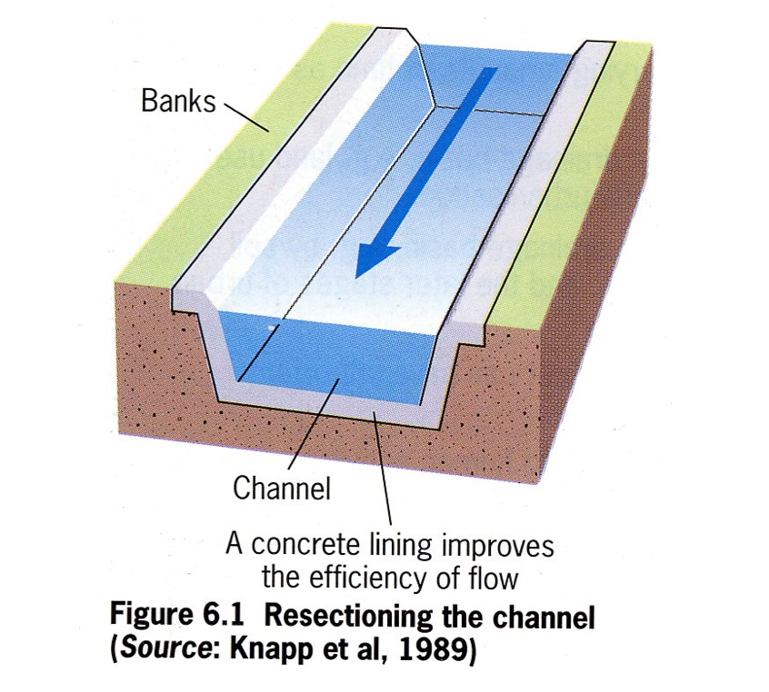
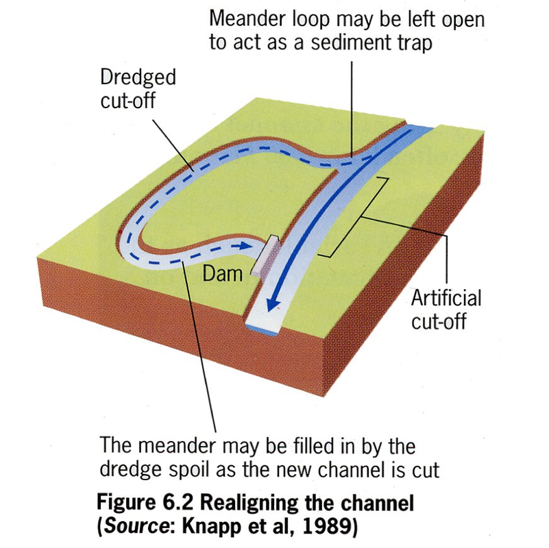
Channelisation
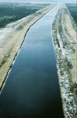
Channelisation is a diliberate attempt to alter the natural geometry of the river. Channelisation can be achieved in many ways. The river can be deepened and widened to increase the capacity of the channel. This increases its hydraulic efficiency and allows a larger discharge to be contained within the channel. This wil hlep prevent flooding. The channel can be made straighter, through the use of artificial cut-offs. The channel can be realligned to artificially increase the long profile gradient so that there is an increase in velocity and flood waters can be removed more quickly, which speeds up the flow and also aid navigation. Channelisation is often achieved through concrete lining the banks and bed. This prevents bed or bank erosion.
Alongside channelisation, engineering and drianage of the floodplian aids reclamation of the wetland. Through drainage and a contained river the water tablef alls. This makes farm land more manageable, creates space for urban developments such as housing and industry. At the local scale channelisation allows for bridges and other transport infrastructure to be built more easily.
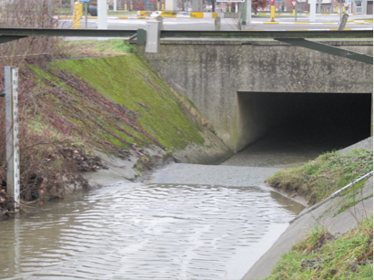
In dense urban environments containment can be used. This is an extreme form of channelisation, which is bulit underground and contains rivers in sub-surface tunnels. They are extremely useful enabling dual use of urban environments, such ring roads, businesses and houses. They do have to be carefully managed to ensure blockages don't exacerbate flood events. In general channelisation is seen as an efffective means of increasing the capacity, hydraulic efficiency and discharge of rivers. It has been successfully used to prevent erosion and flooding for large river systems like the Mississippi, but there remains some significant questions in regard to cost, ecological impact and their effectiveness to cope with high magnitude low frequency flood events.
Alongside channelisation, engineering and drianage of the floodplian aids reclamation of the wetland. Through drainage and a contained river the water tablef alls. This makes farm land more manageable, creates space for urban developments such as housing and industry. At the local scale channelisation allows for bridges and other transport infrastructure to be built more easily.
In dense urban environments containment can be used. This is an extreme form of channelisation, which is bulit underground and contains rivers in sub-surface tunnels. They are extremely useful enabling dual use of urban environments, such ring roads, businesses and houses. They do have to be carefully managed to ensure blockages don't exacerbate flood events. In general channelisation is seen as an efffective means of increasing the capacity, hydraulic efficiency and discharge of rivers. It has been successfully used to prevent erosion and flooding for large river systems like the Mississippi, but there remains some significant questions in regard to cost, ecological impact and their effectiveness to cope with high magnitude low frequency flood events.
Containment channels in Leuven, Belgium
|
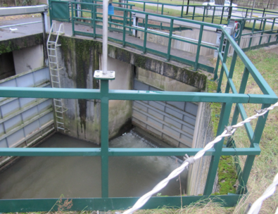
Diversion channels and sluice gates, Leuven Belgium
|
Dredging
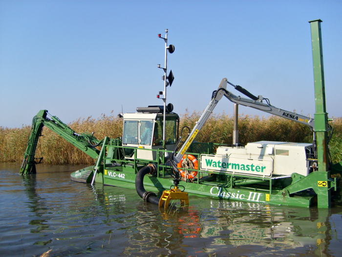
Dredging
Dredging the river is the process by which bedload is removed from the channel of the river. This is achieved through either heavy industrial pumps and diggers or through dislodging sediment that then encourages the natural flow of the river to transport it. The purpose of the river is to increase the cross-sectional area to reduce channel roughness and increase capacity and hydraulic efficiency. The benefit of using dredging is that it maintains the natural aesthetics of the river channel. However, it is costly and time consuming process that is only suitable for small section of the river, for example close to or within urban environments. In addition, the prosess has high ecological impact on natural ecology.
Soft Engineering
Bank Protection, groynes and gabions
Bank Protection
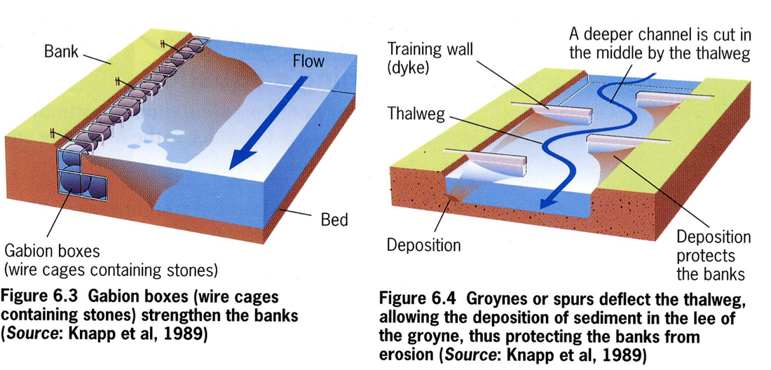
The purpose of bank protection is to help prevent bank erosion. This can be achieved through providing bank support. There are a number of different methods. Gabions, which are wire cages containing stones allow for a softer appearance. If used in the right way they can also encourage deposition close to the banks, which over time, will build up deposition and riparian vegetation. Groynes or spurs achieve the same affect through deflecting the fastest flow away from the bank; deposition builds up on the headward side of the groyne. Over time, riparian vegetation will develop. An even softer approach is the planting of bank vegetation or by allowing vegetation to develop. This is achieved by simply not cutting it back. This will have different consequences depending on the aim. Tree planting along the banks provides greater stabilty and may reduce erosion. However. allowing vegetation to recover in a unregulated way may in fact encourage greater channel roughness and meander migration. When combined with the dismantling of floodpalin drainage the effect would be a rise in the watertable and an increase in the liklihood of floods. In contrast vegetation clearance reduces channel roughness, discourages bank deposition and increases the hydraulic efficiency of the river.
The purpose of bank protection is to help prevent bank erosion. This can be achieved through providing bank support. There are a number of different methods. Gabions, which are wire cages containing stones allow for a softer appearance. If used in the right way they can also encourage deposition close to the banks, which over time, will build up deposition and riparian vegetation. Groynes or spurs achieve the same affect through deflecting the fastest flow away from the bank; deposition builds up on the headward side of the groyne. Over time, riparian vegetation will develop. An even softer approach is the planting of bank vegetation or by allowing vegetation to develop. This is achieved by simply not cutting it back. This will have different consequences depending on the aim. Tree planting along the banks provides greater stabilty and may reduce erosion. However. allowing vegetation to recover in a unregulated way may in fact encourage greater channel roughness and meander migration. When combined with the dismantling of floodpalin drainage the effect would be a rise in the watertable and an increase in the liklihood of floods. In contrast vegetation clearance reduces channel roughness, discourages bank deposition and increases the hydraulic efficiency of the river.
Floodplain Restoration
Increasingly drainage basin managers are realising the importance of the floodplain for its capacity to store water, reduce discharge and recycle harmful agricultural run-off. Floodplain restoration is the process of engineering the river to restore its natural patterns of meander migration and flooding. This can be either achieved over a vast area of river floodplain, like in the case of the River Kissimmee Restoration Project in Florida or localised to protect towns, such as in the case of the River Dijle, in Belgium. Floodplain restoration can be created in two main ways. Firstly, through either the removal of river regulation, as explained earlier through dismantling floodplain drainage and encouraging bank vegetation. Secondly, and more commonly it can be achieved through engineering. In this way the river may be held back at certain points by sluice gates and landscaping, which then create a washland upstream. Alternatively, river flow can be diverted into designated washland space alongside the river. This appraoch was first pioneered in Germany alng the Rhine, with mixed success. There are several important considerations. Washlands only replicate natural floodplains if their scale is large enough to encourage shallow flooding. In Germany, the first flooded washlands were to small and the water level to deep. As a result large animals like deer drowned. Shallow flooding helps encourage greater wetland biodiversity in terms of both flora and fauna, deep flooding detsroys it. A second consideration is the frequency of inundation. Natural floodplains in unregulated rivers flood reguarly and so the ecology is unique and diverse and adapted to that frequency. Artificial washlands are often used as a back-up for already existing river managemet plans. As a result the discharge in the river is seldom at a level that requires their use. As a consequence, very little wetland ecology and biodiversity struggles to establish itself.
Enhancing River Ecology
In other river management schemes the emphasis is not placed on flood management but on restoring and enhancing the natural river ecology. The aim of these projects is to creae features such as greater sinuosity and flow diversity, riparian pond habitats and emergent marginal habitats. The historical context of how British natural river systems were lost and the restoration project in the River Hampshire Avon, in Wiltshire is superbly explained in the following video:
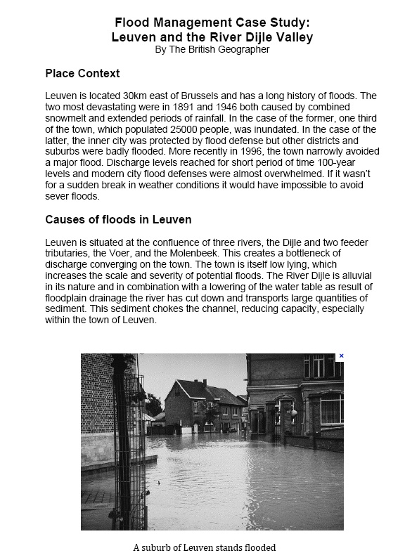
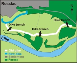
Flood Management Case Study: Leuven and the River Dijle Valley