|
|
|
Glacial Environments
Glacial environments represent very harsh but beautiful environments and are located in the polar regions or in high mountainous regions. Glaciers are made of solid compacted snow that forms ice. There are several types of glacier, including cirques, valley glaciers, piedmonts and ice sheets. Glaciers change size throughout the year as well as over longer periods of time.
Glacial environments represent very harsh but beautiful environments and are located in the polar regions or in high mountainous regions. Glaciers are made of solid compacted snow that forms ice. There are several types of glacier, including cirques, valley glaciers, piedmonts and ice sheets. Glaciers change size throughout the year as well as over longer periods of time.
|
|
Glacial Systems
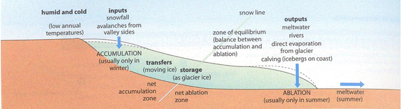
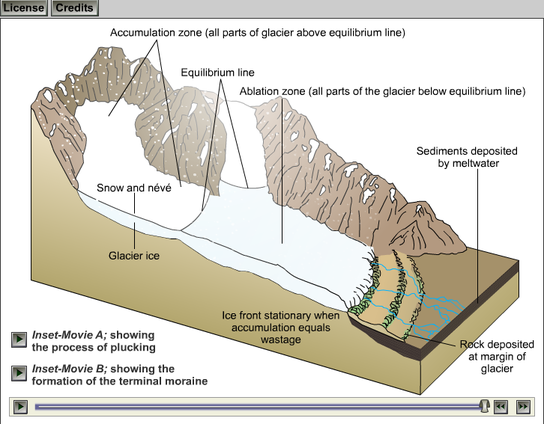
Glaciers can be viewed as a system with its balance between inputs, storages and outputs. Inputs include the accumulation of snow and debris. The glacier is also subject to heating processes and carries meltwater. The area of inputs is called the zone of accumulation. The main storage is ice but also debris that becomes locked inside the glacier and transported as moraine. There are different types of moraine, sub glacial moraine, englacial morain and medial moraine. The output is mainly meltwater and calfing sections of ice. This meltwater transports debris from within the glacier. This area of output is called the zone of ablation. The regime of a glacier refers to whether the glacier is in a stage of advance or in retreat. If accumulation exceeds ablation then the glacier will advance. If the ablation exceeds accumulation then the glacier will retreat.
|

|
How glaciers form
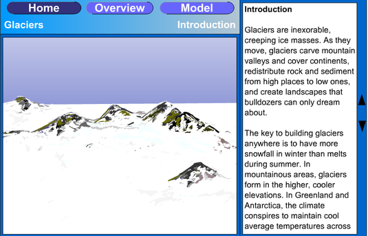
Glaciers form from continued snowfall. As snow falls each year, it accumulates above the snow fall of previous years. This snow compacts, melts and compacts further to form neve. If this compacted snow remains beyond its first year it becomes firn. Over time it becomes so compacted and pressurised by the snow above it that it forms a glacier, with the air pressed out. As enough ice forms it slowly begins to push down the slope. Glacial movement can be likened to a conveyer process and as glaciers move they form distinct landforms from their bulldozing strength.
|
|
|
Glacial Landforms
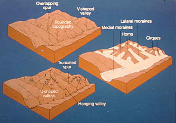
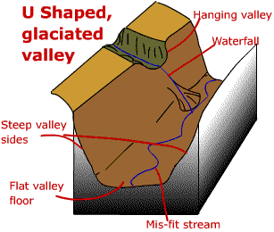
Glaciers have massive capacity to erode landscapes, due to their vast size, weight and constant movement. The diagram below left shows the mountain landscape before glaciation, during glaciation and after glaciation. In the first image the landscape is more rounded with v-shaped valley and interlocking spurs. This is typical of a landscape shaped by rivers. The second image shows how cirque glaciers develop in small hollows in the high peaks and then begin to grow forcing their way and eroding through valleys. The final image shows the landscape after glaciation and reveals a dramatically different topography. It now features deep and wide u-shaped glaciers and hanging valleys as well as tarn lakes in the hollow basin of the former cirque glaciers. U-shaped valleys can later fill with fresh water called ribbon lakes or during time of sea level rise they can be submerged forming fjords.
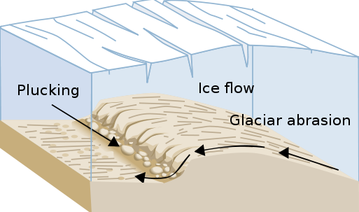
Rates of glacial erosion vary depending on the size and weight of the glacier, the type of rock, the speed of glacial movement and the types of moraine being transported in the glacier as well through subglacial streams. Glaciers erode in two ways. Firstly, through plucking, which occurs as ice rips rock away from the valley floor or side. Rates of plucking are greatest in heavily jointed rock where processes of
freeze-thaw action are present and subglacial streams flow. Secondly, the glacier erodes through abrasion. Rock moraine carried in glacier scours the valley floor and sides as the |
glacier moves. Evidence of abrasion can be seen in marks in the rock in post glacial environments called striations.
|
Source: Wikapedia
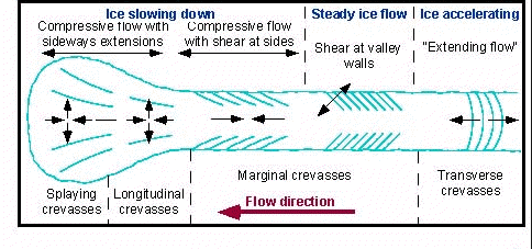
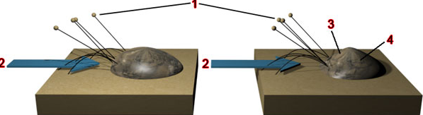
There are many types of glacial landform. Firstly a glacier has many features of its own. The most notorious being crevasses. Crevasses form due to tensional and compressional stresses in the glacier as it moves. The diagram below illustrates the types of crevasses. A more important crevasse is the Bergschrund crevasse, which form from tensional stresses in the glacier as its movement speeds up. This forms a vertical crevasse in the glacier and allows meltwater and debris to enter the glacier.
Source: Rosssea.info
|
Source: ASF Alaska
|
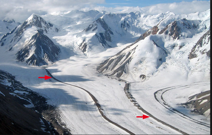
Glaciers are also often quite dirty as they collect debris from rock fall as well as dust and ash (Iceland). This debris forms recognisable features called moraine. There are several different types of moraine in and around glaciers. The diagram and photo below show them.

|
Source: Swissedu
|
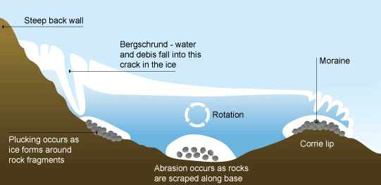
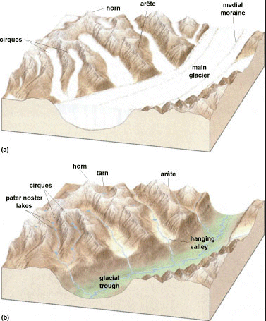
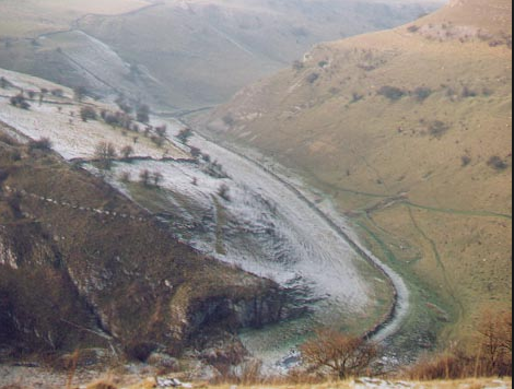
The back wall of the cirque is steepened by plucking and freeze-thaw action and subglacial moraine scours the base of the hollow through abrasion further deepening. Abrasion is greatest at the point of deepest ice due to the weight above it. This results in a characteristic armchair shape to the basin, often filled with a tarn or cirque or corrie lake. Moraine accumulates at the snout of the cirque to form a lip, which acts as a natural dam for the tarn. The tarn is a lake that forms in the cirque after glaciation. 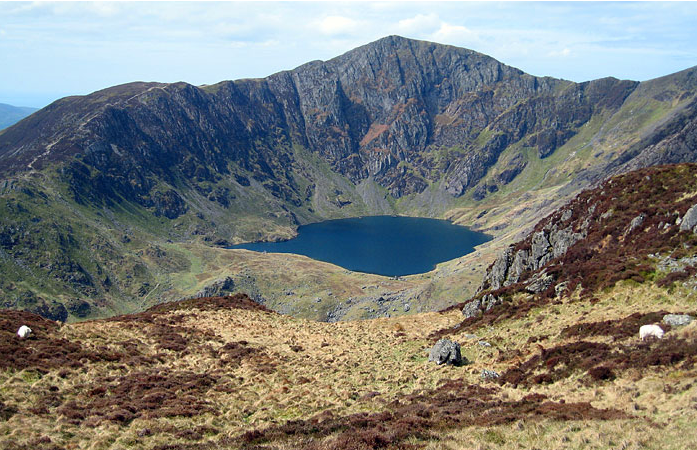
Cwm Cau on the peak of Cadair Idris, Snowdonia National Park, Wales. Photo M. J. Hambrey
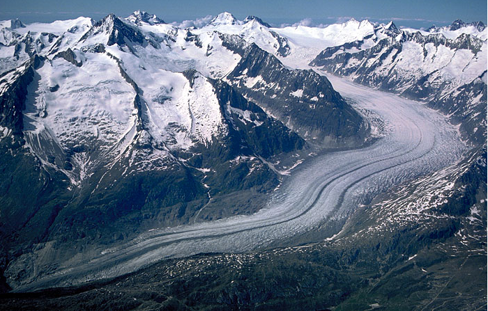
U-shaped Valleys and Hanging Valleys
As glaciers move down valley they continue to reshape it. Valley glaciers are much bigger than cirque glaciers and carry much greater mass of ice. This enables them to erode through abrasion and plucking at a much faster rate. The resulting landform after glaciation is a deep and wide U-shaped valley, with truncated spurs. In post-glacial environments where smaller tributary glaciers have fed into the larger valley glacier, hanging valleys can be found. These are tall plunging waterfalls. The smaller tributary glacier being smaller in mass had less capacity to erode. 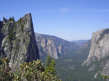
Yosemite National Park, USA

|
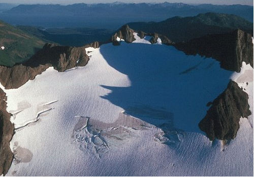
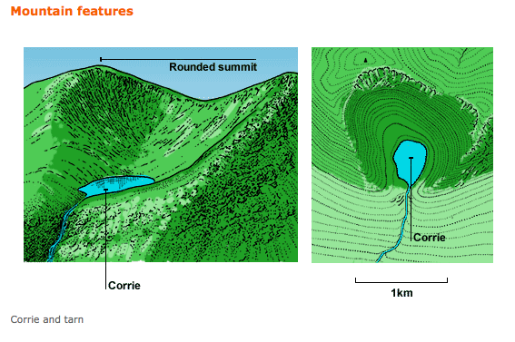
Cirque Glaciers
Cirque glaciers (corrie) are the nesting grounds for glacier development. They form in small hollows of high north facing slopes (northern hemisphere). Freeze-thaw action and snowmelt in a process called nivation deepen hollows where snow can accumulate. Over time ice collects and glaciers develop and begin to move downslope in a rotational manner. 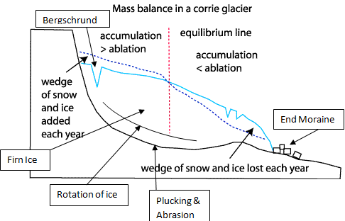
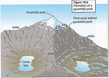
Pyrimidal Peaks, Horns and Aretes When a cluster of cirques form around the slopes of a high peak then pyrimidal peaks and horns are able to form. One feature of a cirque in a post glacial environment is its steep back wall. As these walls deepen in height and gradient on multiple faces of a peak they form pyramidal peaks and horns. Along the edge separating two cirques, razor sharp aretes develop, along which mountain climbers navigate their way to the summit. 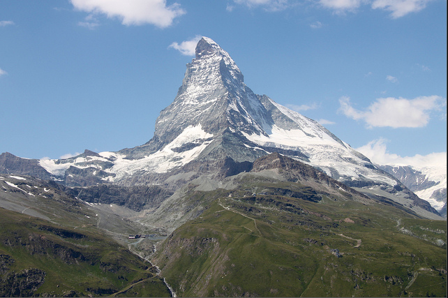
The Matterhorn, Switzerland
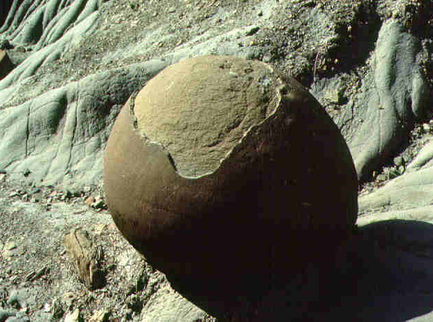
Roche moutonnée
These are bare mounds of rock found typically in U-shaped valleys. They form on the base of the moving glaciers through the process of abrasion and plucking. On the stoss side, (upflow) the rock is scoured by abrasion but as the glacier accelerates on the leeside, (downflow) rock is plucked away. There is inevitably greater freeze-thaw action and meltwater present on the leeside. 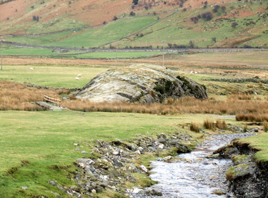
A roche moutonnée: Nant Franccon, Snowdonia, Wales
|
Higher Bitesize geography linked to through the image illustrates glacial topography through good contour maps
Source: Higher Bitesize
Case Study: Snowdonia

Source: NST Group
|
|
|
|
|
|
Glacial Deposition
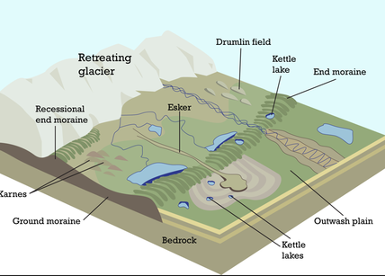
Due to their capacity to erode glaciers transport an emormous quantity of debris. Where this debris collects in recognisable heaps and lines it's called moraine. Once the glacier is in retreat, due to a negative net balance in its regime, a lot of its debris is deposited. Debris deposited by a glacier is called till and can be further divided into lodgement till and ablation till. Lodgement till is debris deposited by actively moving glaciers and ablation till refers to debris deposited by glaciers either in retreat or standing still. Till consists of angular and unsorted debris of varying size. Unsorted means it's not stratified in size like a river floodplain stratifies its load. The debris is often of a variety of rock types, resulting from the distance the glacier may have moved. The direction of glacial movement is identifiable in the field by the direction of the longest length.
The diagrams below show a normal stratified till profile (left) and a unstratified profile of debris associated with debris avalanches (not glacial).

Source: Science Direct
|

|
|
Moraines form in a variety of locations around advancing and retreating glaciers. As a glacier moves forward it erodes the bedrock it comes against. As a result lateral moraine develops at the sides of the glacier. Medial moraines form as a result of a glacial confluence of two joining glaciers. The furthest point of a glacier's advance is marked by the build up of bulldozed debris called the terminal moraine. Recessional moraine form as a secondary line of heaped debris and marks the point where the glacier remained constant for some time. |

|

Norber erratic, Yorkshire Dales
|
Erratics are large boulders and rocks that are a different type of rock compared to the dominant geology of the area where they stand. Clearly they are only there becuase they have been transported and deposited by a glacier. The Norber erratic to the left shows silurian greywacke and slate on top of a carboniferous limestone plinth. The limestone has been weathered away but has been protected under the erratic.
|
|
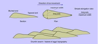
Drumlins are semi-egg shaped mounds that vary in length up to 1.5 km and can be up to 100 meters high. They often form in clusters where the underlying bedrock is irregular and increases friction on the advancing glacier. The glacier deposits debris and shapes it as it continues to advance. Clusters of drumlins are sometimes referred to as basket of egg topography.
|

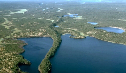
Drumlins from Múlajökull glacier, Iceland
|
Drift refers to deposits left behind by glacial and fluvioglacial processes that result from the melting glacier. Again there are a number of important examples.

Outwash Plain - from Bridgewater Glacier, British Columbia
|
Outwash plains form as a result of the fluvial proceses coming out of the melting snout of the glacier. Due to variations in the glacial regime the outwash plain form a wide and flat plain made up of more sorted, stratified, fine sediments, like sands and gravel. They are found beyond the snout of a glacier. They can also have a several small outlet river channels cutting across them. |
|
Kettles are large depressions in the outwash plain containing water. They form as a result of the calfing and transportation of large sections of ice across the outwash plain. When deposited the ice prevents the laying down of debris at that spot and so the outwash plain builds up around it. This ice can become insulated by debris around it and so can take many years to melt. |

Newly formed Kettles from the Bering Glacier
in southern Alaska.
|
Esker, Northwestern Manitoba, Canada
|
Eskers are long, narrow, winding ridges composed of stratified sand and gravel deposited by a subglacial or englacial meltwater stream. Eskers may range from 5 to 50 meters in height, from 500 meters in width, and a few hundred meters to tens of kilometers in length. |
|
|
|
Periglacial Enviroments
Periglacial environments are located on the edge of the permanent glacial environments, either in alpine regions or close to polar ice sheet regions. They are characterised by permafrost, which is a large section of permanently frozen ground, with a melted summer surface layer called the active layer. This active layer can be up to 3 meters in depth. There are three different types of permafrost. These are continuous permafrost, discontinuous permafrost and sporadic permafrost. Continuous permafrost covers areas where the only thawing of ground occurs under sea, lakes and rivers. The most extensive areas of continuous permafrost are located in Canada, Alaska and Siberia and can extend to depths as deep as 1500 meters. Discontinuous permafrost sees small scattered unfrozen area developing. A third type of permaforst is sporadic permafrost. This is where small islands of frozen ground occur in a generally unfrozen area.
The climatic conditions for periglacial areas include:
The climatic conditions for periglacial areas include:
- mean average temperature between -1°C and -3°C
- temperature below -10°C for at least 6 months of the year
- low precipitation levels, with mean annual precipitation lower than 1000mms
3 types of permafrost
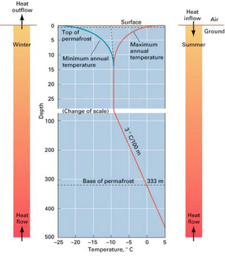
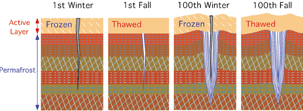
An important feature of permafrost is the active layer. The active layer is the surface area that thaws during warmer summer months. The following two diagrams show the factors of importance relating to the active layer. As you can see in the diagram, permafrost has its own heat budget. In the winter there is net heat loss and the permafrost extends upwards to the surface. During the summer there is net heat gain and the active layer extends deeper.
|

|
The active layer is crucial to many processes and landforms found in periglacial areas. Because only the surface layer of ground thaws and the subsurface layer remains frozen an impermeable cap is found. Thawing of the active layer takes place from the surface and freezing of the active layer takes place from both the surface and the line of permafrost. Occasionally some of the ground remains unfrozen and this soil is known as talik. Talik is thought to occur due to release of latent heat as the active layer freezes.
Pingos
Pingos are dome-shaped hills with a height that ranges anything from 1 to over 60 meters and can be as large as 600 meters in diameter. They develop in areas of continuous permafrost in places like Canada, Alaska, Siberia and Greenland. They can result from two types of process.
Firstly, Mackenzie-type pingos derived from their location in the Mackenzie Delta in Canada are closed systems. They develop beneath lakes surrounded by permafrost. The soil in the centre of the lake remains unfrozen, insulated beneath the water above it and by sediments accumulating in the lake. Overtime the sediments begin to freeze exerting pressure on the unfrozen talik below. Pressure is also increased by the encroaching permaforst below the talik. To relieve the pressure the surface bulges, any reminants of the lake are drained away. Beneath the bulge with the reduced pressure the talik freezes to form a very clear ice core. During melting it's possible that the ice core melts and the pingo collapses in on itself.
Greenland-type pingos are open systems, that are fed by ground water or surface water inputs. This type of pingo form by a process similar to frost heave (explained later). As temperatures fall there is progressive downward freezing of water-saturated soils. As the permaforst encroaches from below pressure is increased and it forces the ground on the surface to bulge upwards This bulge contains frozen saturated soils.
Source: Wikipedia- Pingos near Tuktoyaktuk, Northwest Territories, Canada
|

Source: Wikipedia -Melting pingo and polygon wedge ice near Tuktoyaktuk, Northwest Territories, Canada
|
|
|
|
Permafrost Processes and Features
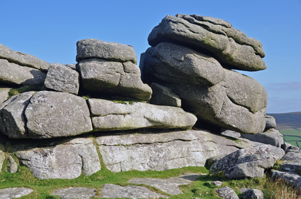
The dominant process in permafrost areas is physical weathering, of which the most important is freeze-thaw action. Due to the abundance of water, hydrolosis is also common. This is the reaction of some minerals with water and the release of weak acids from thawing vegetation. A good example of hydrolisis is the weatheirng of feldspar in granite, which helps form granite tors. Carbonation is also more common because at colder temperatures carbon acid is more soluable and reacts with calcium carbonate in limestone.
Granite Tor
|
The image to the left is of a granite tor. It is characterised by large slabs of unconnected granite. The gaps between the slabs are caused by the hydrolosis of seams of feldspar in the granite. Most debris has long been moved on by processes of solifluction or gelifluction. Solifluction occurs over unfrozen ground when the active layer becomes melted. This creates a fluid topsoil in some areas, which under the influence of gravity will move downslope and transport with it, the fallen pieces of weathered rock. Gelifluction is a similar process but occurs above frozen ground. As the active layer melts, pore pressure develops from excess water in the soil. The frozen ground acts like a shear plane with its impermeability the active layer begins to move down slope.
|
The expansion of water as it turns to ice occurs parallel to the greatest temperature gradient. In this process stones can be pushed upwards. Soil on the surface is is also pushed upwards and can create hummocky ground. This process of water freezing and expanding is called frost heave. A resulting landform on the surface are stones. Stones in the ground retain their temperature longer and so ice lenses build up beneath them forcing them to rise. During the melt, smaller soils and gravel move into the space beneath the stone left behind by the melted ice. As a result every gardener in colder climates will be able to tell you how stones always rise to the surface. On slopes this same process causes stones to move slowly downwards in a process called stone creep. The following video explains how ice lenses form in soils. The second video is just a laugh!
|
|
|
Patterned Ground.
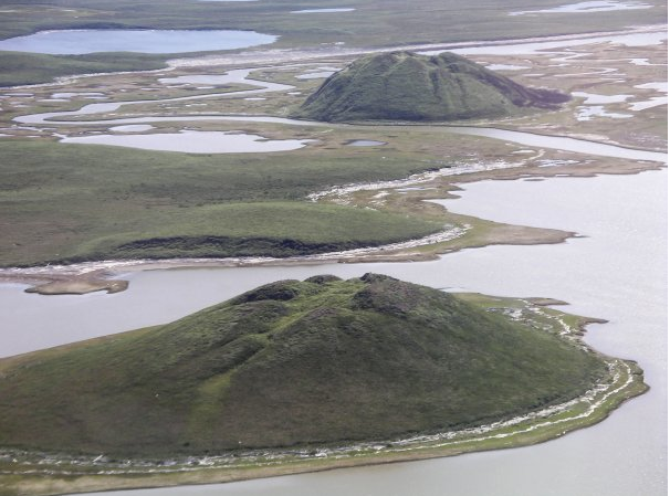
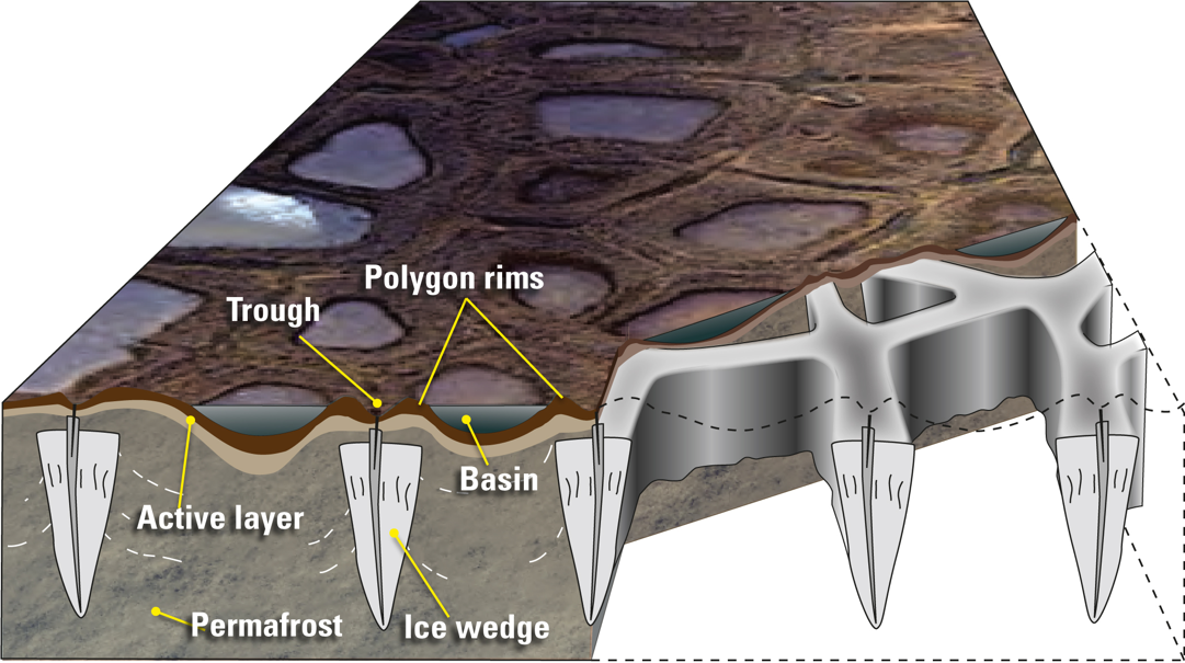
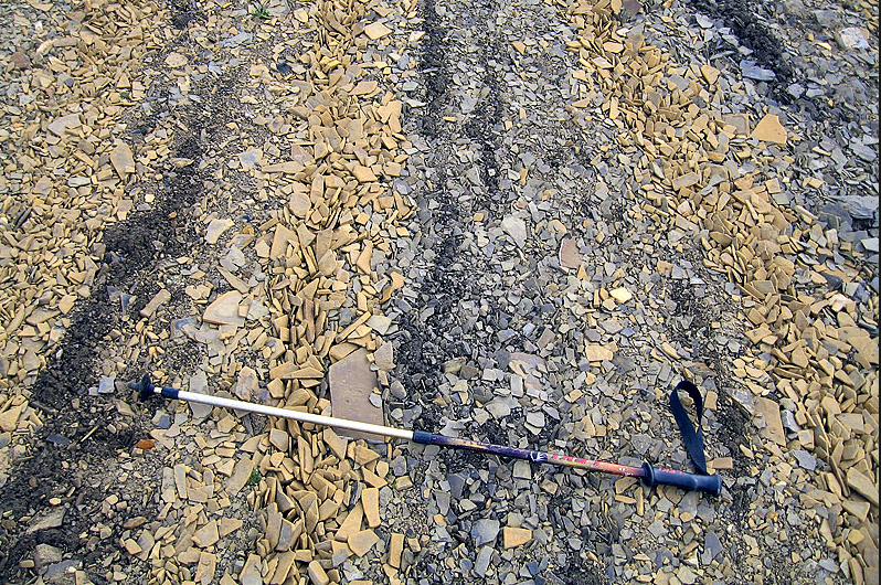
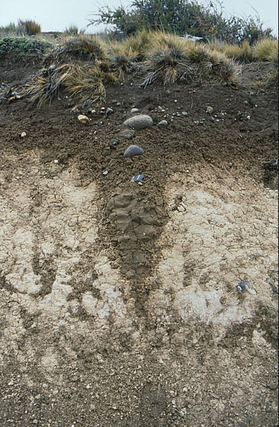
Ice wedges form extensively in periglacial environments. They form as cracks develop during contraction of the permafrost in the winter due to extreme low temperatures. During the spring, the soils expand and moisture collects in the cracks and freezes. Freezing causes the crack to expand and prevents it from closing. The average size of an ice wedge is betwen 15 to 40 meters. In some areas of periglacial environments stones are sorted into regular patterns. There are five types of patterned ground. Stripes and steps that form on slopes (no greater than 30°) and polygons, circles and nets that form on flat slopes.
Stone Stripes
|
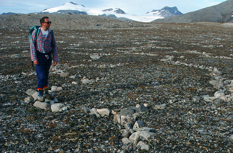
Stone Circles or Polygons
|
Patterned ground is generally thought to occur due to the process of frost heave and dilation. Patterned ground forms through differentiated sorting of stones based on size. Larger stones as they are heaved upwards to the surface are pushed to the side and smaller finer gravels drift inwards probably as a result of ice melt and their susceptibility to movement. This may result in larger stones joining together to form circles or polygons. On steeper slopes circles cannot form but instead develop into stripes. The following diagram from Jane Knight's Advanced Topic master on Glacial and Periglacial environments explains stripe formation very well.
Thermokarst
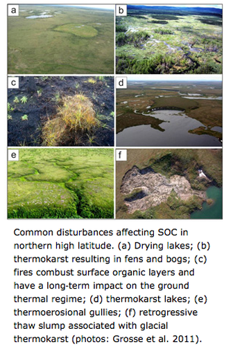
http://www.biology.ufl.edu/permafrostcarbon/thermokarst.html
Thermokarst refers to an area of land surface that forms as the permafrost melts. Melting can be extremely localised and short term caused by for example forest fires or in the longer term, climate change. The most dominant area for widespread occurrence is in northern high latitude permafrost zones. They result not just from top-down thawing of permafrost but also these processes can tap rapidly into deep permafrost. These rapid melting and erosion processes are highly variable. The image to the left shows a variety of thermokarst features. One common feature resulting from melting are alases. Alases are large-scale depressions on the surface that can be between 3 and 40 meters deep and anything from 100 metes to 15km in diameter. It is common that these hollows form lakes and drying lakes as well as a pattern of fens and bogs, retrogressive thaw slumps and thermoerosional gullies and humocky ground. The videos below explain the dynamics of some of the thermokarst features.
|
|
|
In other permafrost areas asymetrical valleys may form. These result from increased thawing cycles on one side compared to the other. In the northern hemisphere this would be the south facing slope compared to the north facing slope. As a result the valley side is more gentle sloping compared to the steep northern side. This is the result of more cycles of solifluction and gelifluction removing the material and creating gentle sloping gradients. This is further enhanced by the lack of vegetation on the northern side, which leads to limited termperature change.
Extensive scree slopes are aslo a common feature of permafrost regions. Scree slopes mostly formed under periglacial conditions as a result of continued freeze-thaw action weathering. Broken rock collects as accumulated scree at the base of the cliff and extends many meters up the slope. As a result the gradient can be significantly changed.
Extensive scree slopes are aslo a common feature of permafrost regions. Scree slopes mostly formed under periglacial conditions as a result of continued freeze-thaw action weathering. Broken rock collects as accumulated scree at the base of the cliff and extends many meters up the slope. As a result the gradient can be significantly changed.
Asymmetrical Valley
Hot Arid Environments
Hot and arid environments have many characteristic landforms, many of which are closely related to processes of weathering and erosion from wind and water. The relative importance of which remains a subject of debate. The range of landforms found in arid environments is determined by the:
- rates of weathering
- the underlying geology
- processes of erosion
- wind action
- water action
Exfoliation
|
Weathering is the process of breaking down of rock in situ. It is the most important process leading to rock disintegration. The rates of weathering, which are very high in arid environments depend on the climate, the type of rock and the type of stress-strain behaviour of rock.
A bi-product of the weathering process is regolith. Regolith is unconsolidated material found above the solid rock. Regolith can be eroded and transported easily and can be involved in the erosion of other material in the formation of some unique arid environment landforms. e.g. desert arches. There are two main types of weathering in arid environments. physical and chemical weathering. Physical weathering is the breaking down of rock by mechanical forces and chemical weathering is the breaking down of rock through changes in its chemical composition. |
Physical Weathering
The most dominant type of weathering in arid environments is physical weathering. There are many types of physical weathering.
Chemical Weathering
Due to the limited supply of water in arid environments, chemical weathering is not as important as physical weatheirng. However, its process is present. Rainfall can infiltrate rocks through pores and joints where chemical processes can weaken the rock. Fogs and dew can also deposit moisture on rock and add to ground moisture.
The following image links to a fabulous resource on types of weathering and environments.
The most dominant type of weathering in arid environments is physical weathering. There are many types of physical weathering.
- Insolation Weathering
- There are three main types of insolation weathering. Granular disintegration occurs due to different rates of heating and cooling within different minerals within the rock. e.g. dark minerals will heat up and expand more than white minerals. As a result the rock will slowly disintegrate due to repeated expansion and contraction. Exfoliation occurs due to the outer layers of rock heating up and expanding faster than inner layers of rock. Later contraction exerts pressure on the rock and as a result the rock appears to peel. This is sometimes referred to as onion-skin weathering. Block disintegration occurs due to heating and cooling of well jointed rocks and as a result large blocks break away.
- Salt Weathering/ Crystal Growth
- High temperatures draw saline rich moisture to the surface and when it evaporates away salt particles are deposited in cracks and pores of rock. In areas of high insolation salt crystals can expand, for example, sodium sulfate has been known to expand 300 percent. This exerts great pressure on cracks and can lead to both block disintegration and granular disintegration.
- Freeze-thaw Weathering
- Due to a high diurnal temperature range in some deserts water that has found its way into pores and joints in rock freezes at night. Water confined in cracks can expand as much as 9 percent when it freezes and this exerts pressure on the structure of the rock, with the outcome, disintegration and scree. This type of weathering is only possible where there is a supply of mositure and where temperatures fluctuate above and below 0°C. It is common in both the Namib Desert of South East Africa as well as in the arid environments of south east USA.
Chemical Weathering
Due to the limited supply of water in arid environments, chemical weathering is not as important as physical weatheirng. However, its process is present. Rainfall can infiltrate rocks through pores and joints where chemical processes can weaken the rock. Fogs and dew can also deposit moisture on rock and add to ground moisture.
- Wetting and Drying - Repeated expansion and contraction due to the wetting and drying of rock can cause the rock to disintergrate.
- Hydration - The process by which minerals in rock absorb water, which in turn creates internal pressure on the structure of the rock. There can also be a change in chemical composition of rock.
- Oxidation - oygen disolved in water reacts with some minerals to create oxides and hydrooxides. This casuses both a staining of some rocks as well as expansion that weaken the rock.
- Solution - In slightly acidic rainfall some minerals can be disolved. For example the mineral calcite in sandstone can be leached out and this causes flaking of the sandstone.
The following image links to a fabulous resource on types of weathering and environments.
Wind
Wind is able to erode arid environments through two main processes deflation and abrasion. Wind is able to pick up sand and with it erode landscapes to create new landforms.
Deflation is the process by which wind picks up and removes unconsolidated material. This creates deflation hollows, salt lakes and salt pans as well as desert pavements. Abrasion is when the wind carrying sand through suspension erodes the surface or rock like sandpaper. This creates landforms such as sculptured rocks like ventifacts and zeugans.
Deflation is the process by which wind picks up and removes unconsolidated material. This creates deflation hollows, salt lakes and salt pans as well as desert pavements. Abrasion is when the wind carrying sand through suspension erodes the surface or rock like sandpaper. This creates landforms such as sculptured rocks like ventifacts and zeugans.

Most deserts are covered in desert pavement not sand and the most likely theory of their formation relates to the removal of sand and fine clays via the process of deflation that reveals larger stones and pebbles that can't be transported by wind.
|
|
Wind abrasion is a key process in forming different stone and rock features. A ventifact is a stone that has been shaped by the wind-blown sand. It has a faceted windward side and a gentle sloping protected windward side. In an area where there is more than one dominant wind direction ventifacts may have two or three facets. With sand abrasion taking place close to the surface it is common that abrasion affects the lower part of larger rocks greater than the top. In this way amazing rock structures like pedestal rocks or mushroom rocks form.
Ventifact formation
|

Source: National geographic, Pedestal rock, Niger
|
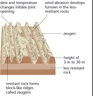
A similar process forms zeugans, which are narrow ridges of land. They have a cap rock of more resistent rock above. They form due to the layering of rock of differing resistence. This lithology allows different rates of erosion. The following video, Earth The Power of the Planet at 20 minutes shows the amazing influence of wind sculpting rocks in arid environments.
|
|
|
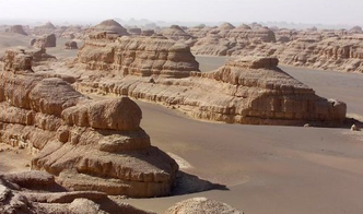
On a larger scale rocks can be sculptured to form yardangs. These are steep crested linear ridges. They are mainly formed by abrasion but deflation may also be taking place in the troughs between the ridges. They have steep facing windward sides that face the prevailing wind and gentle sloping leeward sides and can reach lengths of several kilometers.
|
Yardangs
|
|
|
|
Desert Landforms

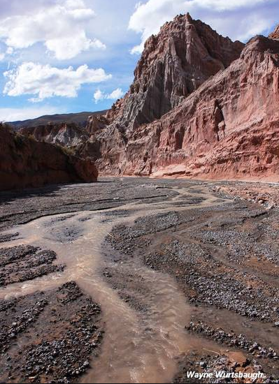
Desert landforms experience such rapid rates of weathering that many of the larger landforms have flat tops or plateaus. Larger mountains are called plateaus and these have been eroded by water, often over very large time scales. Whilst water is a scarce resource in arid environments it doesn't mean that its influence is non-existent. Non-intensive rainfall is evaporated away and has little impact except perhaps from infiltration and weathering. However, intensive rainfall that results from convectional storms and orgagraphic rain can cause major surface run-off events that form fast flowing rivers. These desert rivers called wadis are mostly dry river beds, characterised by wide channels and steep river banks. They are cluttered with bedload. These short term rivers are called ephemeral. Wadis are most erosive in their upper reaches and are able to cut out deep channels. However, as the wadi extends further dowin its course it loses water through evaporation and its capacity to transport river load falls. This leads to deposition in the river channel and braiding.

Wadi - Morocco
In some mountainous areas where potential energy to vertically erode is greater, wadis are able to cut down to form canyons, such as the Grand Canyon of Colorado. The main method of erosion is through abrasion, whereby transported load scours the base of the river channel. These canyons can also be increased by tectonic processes and or isotatic rebound where the geology is raised up. During times of low flow the river deposits its load and the channel braides within the canyon.
|
|

The Grand Canyon, Colorado
|

San Juan River, Goosenecks, Utah
|
Pedimonts, Messas, Buttes and Spires
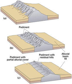
These desert landforms all result from the process of parallel retreat. Parallel retreat occurs because the rock is removed at the base of the cliff through rapid surface run-off and weathering. The resulting landforms produce a gentle sloping platform called a pediment at the base of cliffs, at an angle of 7°. The pediment is sometimes made of solid bedrock but often supports unconsolidated debris and is the most common desert landform. In the diagram below you can observe how the pediment forms at the same time as the cliff or plateau retreats. The pediment forms in a very similar to how wave-cut platfroms are produced at coasts.
|
Messas, buttes and spires are landforms that are remnants of hills and plateaus that have become isolated by weathering and erosion. The desert landscape is often cluttered with plateaus and messas, through the erosional power of wadis and canyons that have left isolated flat-topped hills. The process can be easily seen in the photo of Gossenecks above. Messas are characterised by flat tops, steep cliffs and a sloping pediment covered with debis at its base. The mesa becomes eroded over time untill it is no longer wider than it is in height. At this point it becomes a butte. Further erosion results in a thin column-like formation called a spire.
|

|
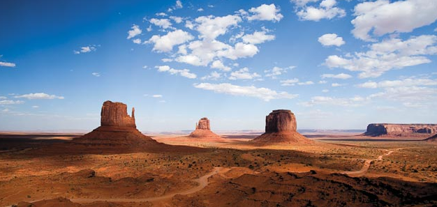
Monument Valley, Arizona
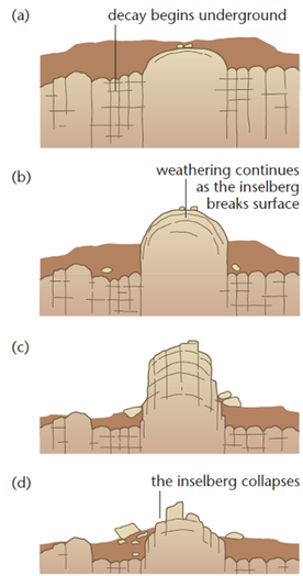
These landforms tend to form in sedimentary rock. However in more resistent geology, such as granite more rounded featured form. Inselbergs are landforms, similar to messas but their erosion resulted at a time of more intensive rainfall.
|
Rainfall infiltrates the rock and chemical action weathers crystals and minerals. Overtime weathered material is washed away by surface run-off.
|
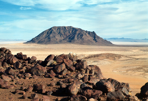
Dicker Willem Inselberg, Namib Desrt
Depositional Features
Because arid environments are prone to flash floods it is common to find a number of depositional features for example during low flow, wadis in-fill with load. At the base of plateaus alluvium fans form. The fans form as perennial or ephemeral rivers move out from a mountainous area into a flat plain. |
As the river meets the plain it slows down and spreads out into a fan shape. As it loses energy from friction it begins to deposit its load and the river breaks up into separate distributuries across the alluvium fan. Where a number of parallel wadis emerge from a mountainous area a series of alluvium fans develop that join together. This forms a continuous pattern of sediment fans covering the lower slopes called Bajadas.
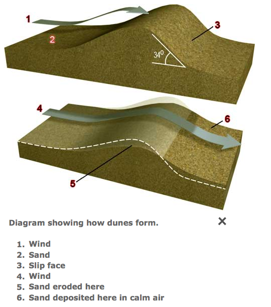
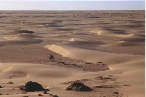
Dunes
Dunes form in sandy desrts like the Sahara Desert. Wind carries and bounces sand grains over the ground surface through processes of suspension and saltation. Small depressions or obstacles slow the wind down through friction and the wind drops its load of sand. The growing mound forms a bigger and bigger barrier to the wind. Over time a crest develops at the top of the mound. Eventually the crest collapses and sand grains fall down a slipface.
Dunes form in sandy desrts like the Sahara Desert. Wind carries and bounces sand grains over the ground surface through processes of suspension and saltation. Small depressions or obstacles slow the wind down through friction and the wind drops its load of sand. The growing mound forms a bigger and bigger barrier to the wind. Over time a crest develops at the top of the mound. Eventually the crest collapses and sand grains fall down a slipface.
Source: Images from www.onegeology.org
|
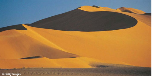
Star Dunes
There are a number of different types of desert dune. Star Dunes form crests with an irregular pattern or wave like pattern and have a number of slipfaces at diiferent directions. Transverse dunes form where there is a lot of sand and the wind blows in one direction. Barchan dunes form where there isn't very much sand and the wind blows in one direction. These dunes are also called crescent dunes. The tips of the crescents point downwind. |
Barchan Dunes
|

Transverse Dunes
|
|
|
|
Flash Floods
Flash floods are common in desert environments and occur due to a number of physical factors. These include, short spells of intense rainfall, steep relief that channels run-off via wadis, gullies and arroyos, dry, sun baked soils and deflation influenced desert pavements that act as impermeable barriers to infiltration and cause rapid run-off. Finally limited vegetation to intercept, absorb and slow down precipitation and run-off.
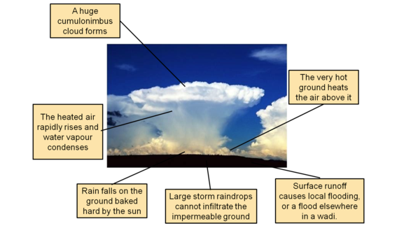
Rainfall whilst infrequent in arid environments tends to be intense when it does fall. Sub tropical environments have a climate that is characterised by seasonal rain. This wet season tracks the movement of the ITCZ. Thus in many arid places rainfall is a typical climate pattern. Due the intensity of the sun, strong convectional processes can draw moisture from the ground and deliver short but intense rainfall events.
Rainfall whilst infrequent in arid environments tends to be intense when it does fall. Sub tropical environments have a climate that is characterised by seasonal rain. This wet season tracks the movement of the ITCZ. Thus in many arid places rainfall is a typical climate pattern. Due the intensity of the sun, strong convectional processes can draw moisture from the ground and deliver short but intense rainfall events.
Source: mrgoldengeography
This rainy season often follows an extended dry season that has dried out surface soils and sediments to produce a hard surface layer that prevents infiltration. In many desert environments because of deflation, the surface is made up of desert pavement, which is very rocky with almost no soil base. This also encourages limited infiltration and run-off. Flash floods have incredible energy and power to erode and transport load. During floods they can expand across large areas of open floodplain and carve out deep canyons within areas of steeper relief. Due to this intense but short lived energy, the river has immense capacity and competence to transport load. Once the feed of run-off is stopped river capacity quickly falls to produce braided channels and rock ladened wadis. The dry channel of a wadi is typically loaded with large angular load in its steeper upper course, which reduces in size the further downstream you go. The following videos capture the erosive power and capacity of desert rivers in a state of flash flood.
|
|
|
