|
|
|
Freshwater Environments and Management
This part of the Freshwater Environments unit is of particular importance to IB Geography. In this section we will look at different types of freshwater environment, including wetland environments and artesian basins. We will also look at some of the issues of managing these environments including, large scale multipurpose dams and resevoirs.
Groundwater Management
Artesian Basins
It is true that most groundwater can be found within a few hundred metres of the surface. Porous rock such as sandstone and limestone contain large quantities of water. These bands of rock are known as the phreatic zone. The upper boundary of this zone is called the water table. The water table rises and falls with seasonal changes. The zone that is prone to seasonal change is called the aeration zone. In some cases groundwater is stored within acquifers that are capped by impermeanble rock layers. In this case the groundwater may take many thousands of years to recycle. These deep groundwater aquifers are great reservoirs of water. The formation of the the Great Artesian Basin in Australia, is well exlained in the following video:
Source: Travelling Australia
|
The Great Artesian Basin, Australia
|
There are a number of layers of groundwater flow within artesian basins. Generally speaking the deeper the flow the longer the time it will spend underground. Groundwater in parts of the Great Artesian Basin is thought to be millions of years old. In this regard we can definitely view it as a non-renewable resource and the process of boring into these ancient acquifers to extract water can be described as mining. Artifcial extraction and exploitation of groundwater resources is a growing problem in many places of the world. Extraction is used for irrigation and water supply. Continued over extraction, whereby more water is removed from the acquifer than can be naturally or (artificially) recharged, leads to a fall in groundwater levels and water quality. In India in 2004, almost one third of its groundwater reserves were described as critical, semi-critical or over exploited, with the World Bank suggesting that 15% of the groundwater stores were being extracted at unsustainable rates. This over exploitation can lead to greater salinisation and lower field productivity. In another example, in Bangladesh, one in five of the deep tube wells placed in the 1970s are contaminated with low level arsenic, which is expected to lead to a massive increase in lung, bladder and skin cancers. Doctors were told to expect an epidemic of cancers by 2010. In Australia free flowing bores bring water to the surface and this just evaporates off. This is causing widepread salinisation of topsoils. In many coastal areas, a major problem arises from salt water intrusion. This occurs at the watertable interface between the freshwater and sea water. Due to the extraction of freshwater, salt water intrudes further inland. This leads to the salinisation of top soils and freshwater and reduces field productivity. Another problem associated with over extraction is land subsidence. The USGS picture (bottom left) shows the approximate location of maximum subsidence in the United States identified by research efforts of Dr. Joseph F. Poland (pictured). The signs on the pole show approximate altitude of land surface in 1925, 1955, and 1977. The site is in the San Joaquin Valley southwest of Mendota, California. The most spectacular subsidence due to groundwater extraction is in Mexcico City. Rates of subsidence in some parts of the city are thought to be up to 40cm per year. In other cases subsidence can be sudden and dangerous posing significant risk to people. This can be seen bottom right in Taiyuan, the capital of Shanxi Province.
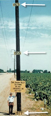
Dr. Joseph F. Poland, San Joaquin Valley
|
Sudden Land Subsidence, Taiyuan
|
There are several ways of recharging aquifers in order to manage these problems. Where the aquifer is made up of impermeable rocks and sediments water spreading is used. This is when water is stored on the surface vais a series of dykes and dams. They are best located in areas that maximise the capture of surface run-off. Water then infiltrates in the ground. In areas where impermeable cap rock lie above the aquifer. Water can be pumped into deep wells. This method is used extensively in the coastal plains of Israel. This helps prevent salt water intrusion. Recharge also occurs as a natural process through infiltration and percolation and through leakages from adjacent aquifers. Where humans have used dams for reservoir storage rates of infiltration increase.
Wetland Environments
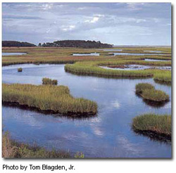
Wetlands are areas where water covers the soil, or is present either at or near the surface of the soil all year or for varying periods of time during the year. Water saturation largely determines the soil and the types of plant and animal communities living there. Wetlands may also support both aquatic and terrestrial species. The prolonged presence of water creates conditions that favor the growth of specially adapted plants (hydrophytes) and promote the development of characteristic wetland (hydric) soils. Wetlands vary widely because of regional and local differences in soils, topography, climate, hydrology, water chemistry, vegetation, and other factors, including human disturbance.
Two general categories of wetlands are recognized: coastal or tidal wetlands and inland or non-tidal wetland. For the purpose of this course we will be concentrate on freshwater inland wetlands.
Non-Tidal wetlands are most common on floodplains along rivers and streams (riparian wetlands), in isolated depressions surrounded by dry land, along the margins of lakes and ponds, and in other low-lying areas where the groundwater intercepts the soil surface or where precipitation sufficiently saturates the soil (upland marshes and bogs). Inland wetlands include marshes and wet meadows that are dominated by herbaceous plant cover, swamps that are dominated by shrubs, and wooded swamps that are dominated by trees.
Wetland Values
Wetlands provide many benefits at very little cost. They are unique and vital ecological resources. They contribute to the national economy by producing natural resources and goods. The many different types and locations of wetlands make measuring their benefits difficult. However, there are a number of factors that suggest wetlands have an important role. These reasons include commercial value for the resource they contain, recreational values, in terms of tourism, wildlife habitats, water quality managemen, erosion control, and flood control.
Wetlands contain an abundance of natural resources, including food, fiber, lumber, and energy resources. These wetland resources are considered to be commercially valued at over $10 billion a year in the US alone. Recreational actvity, including hiking, hunting and fishing is thought to be valued at a further $60 million.
Another impotant value is the unique wildlife and vegetation that wetlands support. They are among the most productive natural ecosystems on Earth. They produce great quantities of plants, some unique to wetlands. Wetlands are major breeding grounds for various resident and migratory birds. They are migratory stopovers for many species of waterfowl, wading birds, shorebirds, and songbirds. Without wetlands, these migratory birds would undoubtedly fall in abundance.
Wetlands are also important in the way they interact with the environment around them. They are natural reservoirs and erosion controllers. The ability of wetlands to recycle nutrients and to take suspended materials and chemicals out of the water is a critical and unique function. The vegetation slows the water enough so that sediment and chemicals in the water can settle to the bottom. As the water is cleaned the plants absorb the chemicals that are released. The plants then convert the chemicals to usable substances and eventually pass on these nutrients to the animals in the ecosystem. Vegetated wetlands help to hold together banks of lakes, rivers that are often prone to serious erosion problems. When wetlands are converted and the vegetation is removed or damaged, soil erosion increases. Instead of serving as a sediment trap, wetlands become a sediment source.
Wetlands also help to control flooding. When water levels are high due to flooding, the heavy, spongy vegetation absorbs the water and slows its flow. The combined action of storing and slowing can lower flood heights and reduce the water's erosive power. The presence of only 15% of a watershed in wetlands can reduce flooding peaks by as much as 60%.
The importance of maintaining wetland environments for the services that they offer is recognised through RAMSAR certification. RAMSAR is a globally recognised certification for wetlands of outstanding natural beauty and significance.
Wetlands Under Threat
Terraba Sierpe Wetlands
Population pressure along with farming and house building, gas pipelines, roads, factories and towns are all squeezing wetlands the world over. River regulation through large channelisation projects, floodplain drainage and large-scale and multiple small-scale dams are restricting the abilty of river systems to supply water to wetland environments. Wetland environments rely on frequent inundation to support their rich biodiversity. Without this, many of the trees and plants will die. Ranching and farming serves to drain wetlands to recover land for pasture and crops. Settlement requires flood free zones and people's property needs to be protected. Over extraction and withdrawal from river systems to provide for thirsty cities and inefficient and in places inappropriate farming methods are drying out the world's wetland environments. Wetlands now represent only 6% of the earth's surface. It is thought that the amount of wetalnd area has halfed since 1900.
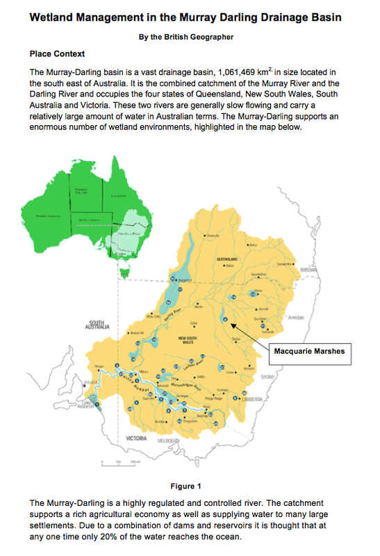
Wetland Management in the Murray-Darling Drainage Basin
The following case study looks at evaluating the management of the Macquarie Marshes in the Murray-Darling drainage basin in New South Wales, Australia. Just click on the first page to open the PDF.
|
|
The Hydrological Changes associated with Multi-purpose Dams and Reservoirs
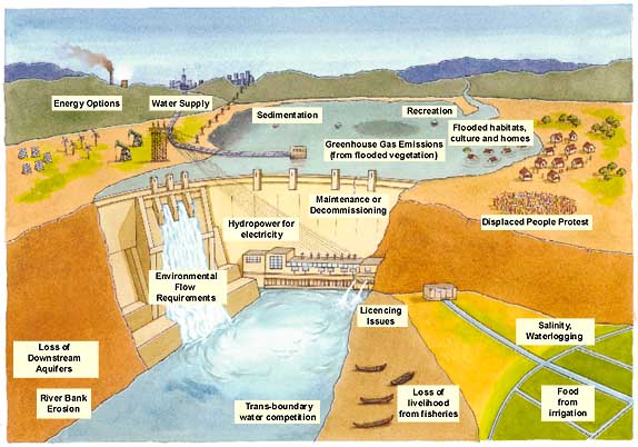
http://www.dams.org/kbase/thematic/issues_diagram.jpg
Large dams and reservoirs have many impacts on the hydrological conditions of the catchment area. The most obvious impact is on discharge. Dams act to hold back the flow of water and in doing so create a reservoir of deep water stored upstream. At the same time, discharge downstream becomes regulated. This at best, can prevent large scale floods and protect lives but at worst, can deprive natural wetlands of vital flows and increase rates of channel erosion due to the extreme variations in discharge. This increase in erosion can cause channel depth to fall resulting in a lowering of the watertable.
Suitable sites for dam projects require steep sided ravine valleys, with considerable depth to store large quantities of water. The water quality of these reservoirs can unfortunately deteriate. Upstream towns and and industry as well as agricultural areas feed a constant supply of sewage, industrial effluence and agricultural run-off into the resevoir. The reservoir also slows down discharge upstream and so these pollutants are not really broken down by the flow of the river. In affect, this can lead to more stagnant waters transporting soild wastes and storing them in the reservoir. The natural flow of water is stopped by the dam and so sediment being transported by the river quickly builds up within the reservoir. This reduces its storage capacity over time and requires long term maintenance. In large reservoirs and where the valley sides are made up of unconsolidated materials, mass movements such as landslides and slumping make occur. This problem is already developing along the sides of the 3-Gorges Reservoir, in China. The problems of water quality and sedimentation are developed in the video below:
Suitable sites for dam projects require steep sided ravine valleys, with considerable depth to store large quantities of water. The water quality of these reservoirs can unfortunately deteriate. Upstream towns and and industry as well as agricultural areas feed a constant supply of sewage, industrial effluence and agricultural run-off into the resevoir. The reservoir also slows down discharge upstream and so these pollutants are not really broken down by the flow of the river. In affect, this can lead to more stagnant waters transporting soild wastes and storing them in the reservoir. The natural flow of water is stopped by the dam and so sediment being transported by the river quickly builds up within the reservoir. This reduces its storage capacity over time and requires long term maintenance. In large reservoirs and where the valley sides are made up of unconsolidated materials, mass movements such as landslides and slumping make occur. This problem is already developing along the sides of the 3-Gorges Reservoir, in China. The problems of water quality and sedimentation are developed in the video below:
This disruption to sediment flow also reduces the amount of sediment being transported downstream. This changes the flow patterns of rivers downstream. This can have negative impacts on farmers who require a rich supply of fertile alluvium. In addition, this interception of sediment reduces the supply to the marine environment, speeding up rates of erosion in delta areas and starving the marine environment of crucial nutrients. When dams are built as part of multi-purpose schemes to produce hydroelectricity it is common for output from the dam to vary over time. Hydroelectricity stations need to be maintained and serviced, therefore river outout and electricity generation is rarely at a maximum. These variations in output have a big impact on downstream hydrology. Increases in flow increase rates of channel erosion. Erosion deepens the river channel and widens the bank, also removing riparian vegetation, which further increase rates of channel erosion. As a result of increased erosion, the water table of the local catchment down stream can fall, making it harder and harder for local farmers to access water. This in turn creates a lowering of downstream aquifers. Large dams also create a problem of cooling the water downstream. Large deep reservoirs store colder water and when released downstream the natural temperature and ecology of the river changes.
The Costs and Benefits of Multi-purpose Dams
The above example of the 3-Gorges dam has become a classic Geography case study for developing the costs and benefits of dams. So it would be wrong not to develop it as an example here. However, in discussing the relevance of large scale multi-purpose dam projects its is important to see them in place context and for this reason we will refer to a number of countries to discuss the importance of dams for their needs. For China, the 3-Gorges has far greater significance than just a large dam that produces electricity it represents China's recent emergence as a global superpower. It represents one of the world's most spectacular engineering feats and was also one of biggest landmark achievements of the 21st Century. Politically this project presents China as a powerful force in the world and it attempts to show the world that China can in someway control mother nature. The shear scale of the 3-Gorges is mind boggling. It's the world's biggest dam and the largest hydroelectric power station. It has flooder over 62,000 acres of farmland, 13 major cities, 140 large, and hundreds of small villages along the river's banks and force the relocation of just shy of 1.5 million people and is expected to grow to 4 million by 2020. Made of concrete and steel, the dam is 2,335 m (7,661 ft) long and the top of the dam is 185 metres (607 ft) above sea level. The project used 27.2 million cubic metres of concrete (mainly for the dam wall), 463,000 tonnes of steel and moved about 102.6 million cubic metres of earth. The concrete dam wall is 181 metres (594 ft) high above the rock basis. When the water level is at its maximum it will reach 75 metres (574 ft) above sea level, which is 110 metres (361 ft) higher than the river level downstream, the dam reservoir is on average about 660 kilometres (410 mi) in length and 1.12 kilometres (3,700 ft) in width. It contains 39.3 km3 of water and has a total surface area of 1,045 square kilometres (403 sq mi). On completion, the reservoir flooded a total area of 632 square kilometres (244 sq mi) of land. It is estimated to cost $22.5 billion.
So how can such a scale of production be justified? Well, there is a lot to be said in criticism of the 3-Gorges Dam. There are a great deal of environmental and social issues, not to mention the potential risks of dam failure. However, it is important to establish some weight of importance in looking at the cost-benefit analysis. I don't think this has really been well addressed in the media or for that matter in text books. So for that reason I would like to be provocative and write a short defense of the 3-Gorges Dam. You can look in more detail at the costs on Jeffrey Hay's site below.
If we consider first then the economics of the 3-Gorges, then China can actually afford it. Through its policy of opening up to the world market and joining the WTO, China has become the 'factory of the world'. In doing so it has created huge revenues, with its balance of payments in trade posting annual positive returns in the hundreds of billions over the last decade. Having said this, China's economy remains immature. Too oversimplify it produces vast amounts of goods that are of low value and it achieves this through low wages and cheap raw materials. In order to mature as an economy and maintain economic growth in the future it needs to increase its value of production and its domestic market. It can do this by shifting to higher value goods and by increasing the purchase power of its population. However, to achieve the latter it must create employment. In the context of having money to burn and the need for job creation, large scale infrastructural projects like 3-Gorges dam fit the bill. 3-Gorges created 60 000 jobs and took over 12 years to build.
Another benefit of 3-Gorges was to help China open up the interior of its country to development. China at present has an immense east/west divide and so the reservoir offfer an important industrial routeway. The reservoir will be deep enough to tansport 10 000 tonne freighters. This offers the cities of the regions along the 660 km length an important trading route.
China is also under large internatonal pressure to take its new global role more seriously. As part of this it needs to be seen to be takling the problem of climate change more. The Dam will reduce at full power, coal consumption by 31 million tonnes per year, avoiding 100 million tonnes of greenhouse gas emissions. At the same time it will provides the world’s largest capacity hydroelectric power station with twenty-nine 700 MW turbines and a total capacity of 20,300 MW. Eventually, it will have 32 generators: 30 main generators, each with a capacity of 700 MW, and two plant power generators, each with capacity of 50 MW, making a total capacity of 22,500 MW. The expected annual electricity generation will be over 100 TWh, 10% of China's current energy requirements.
Finally, one other major benefit of the dam is its flood control. In short, the dam has been estimated to protect 10 million people from the risk of catastrophic floods. In many ways I find myself thinking at this point, end of. If the dam, is able to protect so many people from major floods and considering the Yangtze's long history of major floods and the continued criticism that its government has downplayed the number of fatalities, yet still released the figures suggesting thousands have died in single floods events, then the dam surely justifies itself. I really do see flood defense as being a particularly important benefit. We often hear in regard to criticisms of the dam, about lost cultural heritage and displaced people. I don't wish to suggest that these factors are not important but the 10 million people protected from flooding often gets neglected. There is a really good link to a summary of the costs and benefits below, but the important role that you have in writing about these factors is to assess their relative importance against eachother. For me the 10 million people and 10% (greenhouse gas free) energy are both really difficult to top.
For a full summary of the costs and benefits of the 3-Gorges Dam by Jeffrey Hays can be read on the following webpage
Other Multi-Purpose Dam Projects
In reality, similar to the case that I have just made for 3-Gorges, a full cost- benefit assessment seems to be rarely carried our for multi-purpose dams. This is because dams tend be part of larger political-economic strategy. For example, In India there are are over 4300 large dams but only 27,000 MW of electricity is harnessed out of 150,000 MW potential. It is estimated that between 30 and 40 million people have displaced. The political driver fo these dam is energy. With energy demand growing at 5.2% annually, the government aims to triple the country’s power generation in the next two decade. This includes the Narmada Valley Development Project in Western India. This project is a chain of 3200 dams, including 30 large dams, which completely dams the Narmada River and its tributaries across three states. In addition, India is in the planning phase of an 11 000 MW dam on the Upper Siang in North East India. There appears to be a distinct laissez-faire approach to the planning, construction and evaluation of large scale dams. Arundhatii Roy commented on on the subject, "...the Government has not commissioned a post project evaluation of a single one of its 3,600 dams to gauge whether or not it has achieved what it set out to achieve, whether or not the (always phenomenal) costs were justified, or even what the costs actually were... Isn't this astounding? How can you measure progress if you don't know what it costs and who has paid for it?". It seems quite clear from Roy's perspective that India are following a development strategy that prioritises almost blindly, the economic-energy needs of the country over any social and environmental concerns of dam construction; externalites as economists like to call them. Lets remember, 30-40 million people displaced from 4300 dams simply dwarfs the 1.4 million displaced from 3-Gorges.
There is a clear divide at the global scale, in regard to large-scale dam construction. Worldwide, developed countries seem to have mostly stopped building dams, whilst developing countries seem to be persuing mega-projects. In the past, this has been encouraged by the World Bank as a genuine development strategy but in the last decade or so it has been heavily criticised. Dam construction appears to have served to further indebt developing countries for little gain. At the same developed countries and their corporation have profiteered; all of this alongside the massive social and environmental consequences of dam construction. To investigate this controversy in 1998, the World Bank and World Conservation Commission chartered an expert panel, the World Commission on Dams to review the global controversy over large dams and make recommendations. They concluded, "dams have made an important and significant contribution to human development, and benefits derived from them have been considerable... in too many cases an unacceptable and often unnecessary price has been paid to secure those benefits, especially in social and environmental terms, by people displaced, by communities downstream, by taxpayers and by the natural environment." This is perfectly illustrated in the case of the Akosombo Dam in Ghana. The construction of the Akosombo Dam resulted in the flooding of part of the Volta River Basin and its upstream fields, and in the creation of Lake Volta, which covers 3.6% of Ghana's total land area. The Akosombo Dam and Lake Volta was built between the years of 1961 and 1966, and necessitated the relocation of about 80,000 people, that represented 1% of the population. People of 700 villages were relocated into 52 resettlement villages two years prior to the lake's completion; the resettlement program was under the direction of the VRA. Two percent of the resettled population were riparian fishers and most were subsistence farmers. The project was hailed as largest single development investment in Ghana. The dam provides electricity to Ghana and its neighboring West African countries, including Togo and Benin. Initially 20% of Akosombo Dam's electric output (serving 70% of national demand) was provided to Ghanaians in the form of electricity, the remaining 80% was generated for the American-owned Volta Aluminium Company (VALCO). The Ghana Government was compelled, by contract, to pay for over 50% of the cost of Akosombo’s construction, but the country was allowed only 20% of the power generated. Some commentators are concerned that this is an example of neo-colonilaism. The dam's development was undertaken by the Ghanaian government and funded 25% by the World Bank and bilaterally by the US and the UK.
It is no understatement to say that Ghana has benefitted from the construction of the Akosombo Dam. Since the dam was commissioned the country has seen the supply of electricity to many towns and villages through the national grid and the percentage of electricity now going to Ghana is increasing over time. In addition, electricity was supplied to neighbouring Togo and Benin, which brought in foreign currency. The dam was seen as a vital component for the industrialisation of Ghana. However, much of the negotiated industrialisation failed to arise, including the promised use of Ghana Bauxite by VALCO. It is therefore difficult to ignore the neo-colonialism comment. The UK, US and the World Bank negotiated terms that at best can be described as inbalanced but at worst exploitive.Through their part funding of the project, the US secured 80% of the electricity for VALCO and the UK secured the engineering contract, which in effect, returned their loan directly back into the UK economy.
There is a very good article on Akosombo here
In evaluating the costs and benefits of the multi-purpose dams we should look no further than the recommendations of the World Commission. They suggest that Dams require:
- “demonstrable acceptance” of affected people, based on free, prior, and informed consent
- project planning should include a comprehensive assessment of needs and development options
- that top priority should be maximizing efficiency of existing water and energy systems
- stronger mechanisms for compensation and ecological restoration
The Impacts of Agriculture and Irrigation on Water Quality
Agriculture and irrigation have huge impacts on freshwater quality; rivers, lakes and groundwater are all effected. Water scarcity is ubiquitous in nearly every place where irrigation is being used. Intensive agriculture has deforested vast strands of woodland for ranches and plantations, leading to rivers becoming choked with sediment. Population pressure and monoculture farming in regions like Sub-Saharan Africa has had a similar impact on speeding up soil erosion, which leads to the sedimentation of rivers. Through more intensive farming methods and widespread use of chemical inputs, pesticides and artificial fertilizers leach through soils into groundwater supplies and then transfer through modern field drainage into the rivers. Inefficient irrigation systems have waterlogged fields and increased salinization of soils and water systems. Large dams associated with irrigation systems pollute rivers with cold water. Really, the list just goes on!
Modern agriculture in developed countries, involves high energy inputs, high intensity farming is based on vast irrigation infrastructure. As a consequence, engineering has drained freshwater wetlands, removed forest cover, lowered the water table and reclaimed land for huge farms. The first impact therefore, is the loss of ecology and biodiversity that wetland environments promote and support; as well as the vital environmental services that wetlands offer, in terms of reducing rates of erosion, storing flood run-off and recycling agricultural run-off and solid wastes. With the loss of wetlands all of these services are reduced and freshwater quality falls.
With widespread use of pesticides and artificial fertlizers, there is constant leaching through the soils. Aa a consequence of field drainage these inputs end up in the groundwater and flow into the river. The loss of freshwater wetlands due to channelisation and drainage and the leaching of agricultural run-off into the river is superbly animated in the case of the River Kissimmee in Florida. This can be seen in the video below.
|
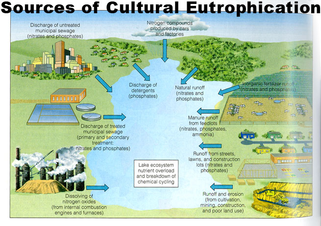
Agricultural run-off is the result of animal waste and phosphorous and nitrate rich chemical fertlizers and pesticides. When these inputs end up in the river or lake they can lead to a reduction in the health of the river through the process of eutrophication. The many sources of nitrate and phosphate, such as animal waste treatment, artificial fertilizers, urban and industrial effluence have coined the phrase cultural eutrophication. This is illustrated in the diagram below, left. |
|
|
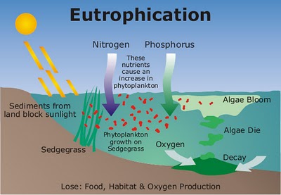
Eutrophication occurs when large quantities of nutrients such as nitrates and phosphates enter the freshwater environment (although it also occurs in marine environments). Nitrates (NO3-) are water-soluble (they dissolve in water), and are applied to agricultural fields as fertilizer. Unlike nitrates, phosphates (PO43-), are not water-soluble. Instead, they adhere to soil particles, and as such, often accumulate in soil and erode along with soil into the freshwater environment. As a result the ecosystem quickly experiences an increase in photosynthetic and blue-green algae, as these organisms thrive in the presence of the added nutrients. An algae bloom occurs as the algae accumulates into dense, visible patches near the surface of the water, prohibiting light from penetrating deeper areas of lake or stream.
|
Some fish are unable to survive without this light. A more serious problem arises however, when the algae begin to die. At this point, oxygen-demanding bacteria take over the ecosystem, decomposing the algae and using up dissolved oxygen in the process. These bacteria increase the biological oxygen demand (BOD) of the ecosystem. BOD is the amount of oxygen required for the decomposition of organic compounds by microorganisms in a given amount of water. It is usually measured in milligrams of oxygen consumed per liter of water. BOD is important because it affects the amount of dissolved oxygen available to all species in the ecosystem. A higher BOD indicates a lower level of dissolved oxygen. This lower concentration of oxygen causes many fish and plant life to die and as they die, the number of oxygen-demanding decomposers increases even more.
In the example of Kissimmee, the problem of eutrophication is not only an issue for the freshwater environment but due to frequent storms interacting with Lake Kissimmee, these stored pollutants rise to the surface of the lake and storm run-off channels release and transport it to the marine environment. It is this run-off that's contributing to the slow acidification of the coastal environment and the loss of some of Florida's coral reefs and fish breeding grounds.
Agriculture and the Impacts of Deforestation on Water Quality

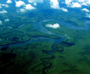
Somewhere in The Amazon
Forests make a significant contribution to maintaining high quality of water in watersheds by preventing soil erosion. Deforestation as a result of population pressure, resource shortage and intensive farming increases the flow of surface water and transports sediment to streams, silting them up and affecting water quality downstream. This is turn reduces the light reaching deeper parts of rivers and lakes.
Forests are more effective than any other type of land cover in preventing erosion as roots, undergrowth and forest litter trap sediment. This is especially true on slopes as trees have a key role in preventing landslides and downward soil movements. Deforestation is affecting vast areas of the world but it makes sense to integrate regions that you are already familiar with. For example, the rapid rates of deforestation in Pakistan, Nepal and Tibet, which have been intergrated with flood events on this website. The loss of forests in these countries is known to be having a dramatic impact on water quality, sedimentation and the frequency and magnitude of floods. When rivers flood there are a whole host of additional secondary impacts to water quality, including sewage pollution.
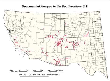
The impacts of soil erosion are also common as result of ineffective land management in arid environments like Sub-Sahran Africa. Countries like Niger have experienced more frequent cycles of drought and as a result of population pressure, leading to deforestation, over-cultivation and over-grazing, soil quality degrades and is quickly eroded by wind and tropical downpours. The evidence of which exposes gully channels, shown below left. Similarly, ineffective irrigation in drier environments like South West USA has led to the development of Arroyos. Arroyos form in irrigation ditches. During storm events large quantities of run-off vertically erode the bed of the ditches. Taking the water level below the field level. In some places Arroyos have been known to cut down as much as 20 metres, leaving the fields useless and leading to massive sedimentation of the river system. The distribution of field sites identifying the location of arroyos in the US is shown in the map.
Forests are more effective than any other type of land cover in preventing erosion as roots, undergrowth and forest litter trap sediment. This is especially true on slopes as trees have a key role in preventing landslides and downward soil movements. Deforestation is affecting vast areas of the world but it makes sense to integrate regions that you are already familiar with. For example, the rapid rates of deforestation in Pakistan, Nepal and Tibet, which have been intergrated with flood events on this website. The loss of forests in these countries is known to be having a dramatic impact on water quality, sedimentation and the frequency and magnitude of floods. When rivers flood there are a whole host of additional secondary impacts to water quality, including sewage pollution.
The impacts of soil erosion are also common as result of ineffective land management in arid environments like Sub-Sahran Africa. Countries like Niger have experienced more frequent cycles of drought and as a result of population pressure, leading to deforestation, over-cultivation and over-grazing, soil quality degrades and is quickly eroded by wind and tropical downpours. The evidence of which exposes gully channels, shown below left. Similarly, ineffective irrigation in drier environments like South West USA has led to the development of Arroyos. Arroyos form in irrigation ditches. During storm events large quantities of run-off vertically erode the bed of the ditches. Taking the water level below the field level. In some places Arroyos have been known to cut down as much as 20 metres, leaving the fields useless and leading to massive sedimentation of the river system. The distribution of field sites identifying the location of arroyos in the US is shown in the map.
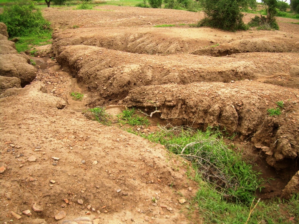
Gullies formed by soil erosion
|
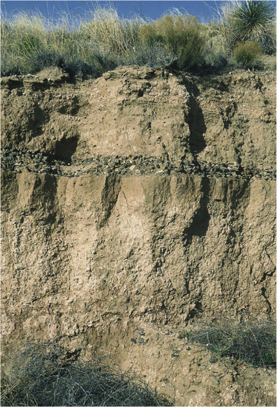
Arroyos lead to sedimentation
|
Agriculture and Salinization of Freshwater
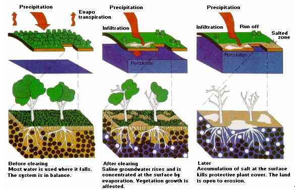
Agriculture with its widespread clearing of native vegetation and replacement with annual crops and pastures has changed the hydrological balance of the landscape. Perennial native vegetation uses most of the rainfall via direct interception by leaves and exploitation of soil moisture by deep root systems. Shallow rooted annual crops and pastures use less rainfall, increasing recharge to groundwater and causing watertables to rise. Dryland salinity can appear anywhere from 20 to 100 years following clearing, depending on the type of groundwater flow system that is operating. Unfortunately dryland salinity is occuring in nearly all dry regions using irrigation schemes. This not only increases salinity in groundwater but also in soil layers, reducing field productivity. Its process is illustrated in the diagram above.
Irrigation is linked to salinization of groundwater and soil layers in a number of ways. All irrigation water contains dissolved salts derived as it passes over and through the land, and rain water also contains some salts. These salts are generally in very low concentration in the water itself. Firstly, in some cases when excess water is supplied to crops it evaporates away leaving salt deposits in surface layers. These can later be leached into water systems. Secondly, irrigation can lead to waterlogging as described above. This occurs when irrigation systems over load the soil with water it cannot utilize. Thirdly, ineffective irrigation in upland farms can lead to saline seapage, whereby saline groundwater flows downslope as throughflow to salinize lowland farmland and water systems. The problem of salinisation is well documented in the Murray-Darling drainage basin, but can generally considered ubiquitous to intensive irrigation schemes. Finally, salinization is also considered a problem in dams associated with irrigation schemes. In this case, increased evaporation rates lead to higher salt levels in the reservoir. When this released it increase salt levels in rivers. Dams also act to cool down water, so as water is released it also inputs unnaturally cold water into the river, which has significant impact on the health and ecology of the river.
The Aral Sea
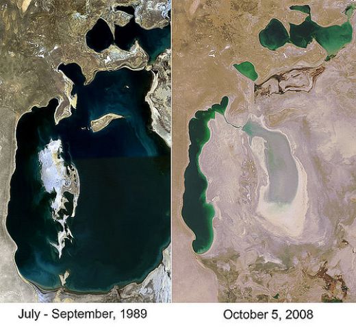
The UN General Secretary Ban Ki-moon recently visited the Aral Sea in Kazakhstan and described it as "...one of the worst environmental disasters in the world". The Large Aral Sea, an inland lake has shrunk in size by 90 per cent since the Soviet Union diverted the waters of the Amudarya and Syrdarya rivers to cotton production in the 1960s. Now all that is left is a toxic desert of shifting sands and marrooned rusting fishing vessels. The Aral Sea as a whole shrank in size from 66,100 kilometres in 1961 to only 10, 400 in 2008. 2012 is expected to witness the complete drying out of the eastern part of the Large Aral Sea. The Aral Sea serves an important role to warn us of the devestating impacts of agriculture on water quality. In this extreme example, we witness the complete loss of a freshwater ecosystem. The scar of its former scale can be seen from space as a reminder of what was once an inland sea with thriving fishing and tourist communities. The former sea bed and its exposed chemicals, transported there as agricultural run-off is whipped up in strong winds. Pandemics of lung infections, tuberculosis, lung cancer, asthma and birth defects are acutely present within the local populations. With the water now almost entirely disappearing in the Large Aral Sea there is no means of storing these chemicals. There is also a sad reality to realise here. The difference between the Aral Sea and many other freshwater environments in the world, perhaps a lot closer to us, is really not so big. For the Aral Sea, the issues are visible, blatantly in your face, the sea has been lost, the chemicals are exposed on the sands of the former seabed and lifted by winds into the atmosphere; people then breath them in and terrible health issues are the measured consequence. Each step of this environmental disaster has been measured and recorded but yet still allowed to happen. For many of the world's other wetland environments the environmental damage is less clear. The same chemicals can be found but they remain stored and silent; their environmental costs less visible but certainly measurable; their social and health impacts more dormant but none-the-less still with us through the food chain.
Simon Reeve describes the impacts of this loss superbly in the video below.
Simon Reeve describes the impacts of this loss superbly in the video below.
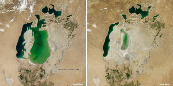
Nasa: The Aral Sea 2000 and 2011
