|
|
|
Coasts of Erosion
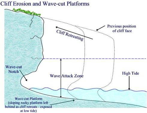
Wave-cut platforms
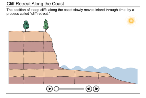
Coasts of erosion form as a result of high energy waves, large fetch, high exposure and limited deposition. They are also associated with drift alligned coasts that are influenced by longshore drift. This transfer of sediment along the coast limits the development of beaches and leads to greater cliff exposure, hence cliff retreat. Coastlines, that are discordant in geology help create typical headland and bay features that also erode over time to form wave-cut platforms and arches and stacks. Wave cut platforms as illustrated in the diagram and shown in the photograph are remnants of the previous cliff line. They form as a ledge of bedrock left behind as the dliff retreats. The platform slopes at at 4-5 degree angle down to the sea. It forms as waves erode the base of the cliff in the
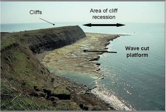
Cliffs and wave-cut platforms
inter-tidal zone. Waves scour away at the base through processes of abrasion, hydraulic action and solution, untill over time a wave-cut notch forms. As the notch enlarges, the cliff face becomes undermined untill at some point it collapases under its own weight. Attrition and transportation then remove the cliff debris leaving behind a small bedrock ledge, which marks the old cliff line. This process is repeated over time as the cliff retreats forming a larger wave-cut platfrom. Eventually a beach may develop on the platform which will provide some protection to the cliff and in turn slows down the rate of retreat. Wave-cut platforms are characterised by their gentle sloping angle, hard bedrock and rock pools, which develop unique coastal ecosytems. This is superbly animated below.
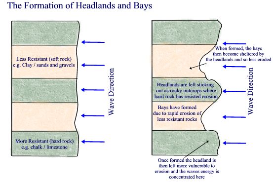
Headlands and Bays
Headlands and Bays
Source: GeobytesGCSE
Headlands and bays are most commonly found at discordant coastlines where the cliif is subject to differentiated rates of erosion, due to bands of of varying resistant geology. However, as already explained, they also form at concordant coasts and in sections of cliff that have more distinct lines of weakness. Bays are sheltered, low energy zones that form in bands of weak geology, e.g. clays. Here the cliff erodes at a faster rate. Bays are flanked by headlands which are exposed rocky outcrops positioned at 90 perpendicular to the bay. They consist of more resistant rock, e.g. limestone. Due to the way waves refract around headlands, destructive waves concentrate their energy on their sides and over time develop unique coastal features, such as caves, arches and stacks.
Wave refraction is the process by which waves become distorted by differentiated rates of friction caused by shallower water ahead of coastal features. In deep water waves are unaffected but in shallow water waves slow down. On approaching the shorline waves will curve in to beaches and reducer the liklihood of drift. Waves approaching headlands slow down and bbuild height creating destructive waves, The waves become refracted around the headland and so wave energy becomes concentrated on the sides of the headland. Wave refraction is superbly explained and illustrated in the following animation:
Caves, Arches, Stacks and Stumps
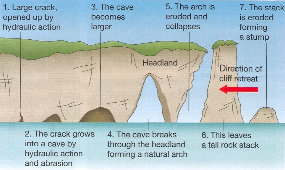
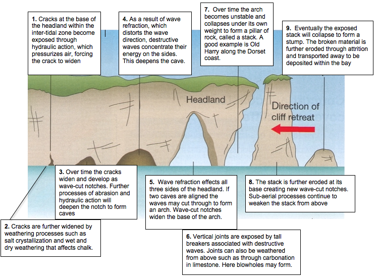
Headlands, once formed, are exposed to the full force of the sea. As a result of wave refraction, destructive waves concentrate their energy on all three sides of the headland and so it slowly erodes overtime. In doing so, quite distinct features develop. In Geography, the erosion of headlands in developing the sequence of cave to stumps is well developed, but how is it extended at the Post 16 level. There isn't a great deal of complexity in understanding and explaining how the features develop over time but clear exemplification is required as well as a clear sequence. The diagram below left, shows a well annotated headland, (at the (I)GCSE level) and it explains how headlands erode over time. It also shows the sequence through numbering. The second diagram shows a Post 16 model example. This shows how vocabulary is used to exemplify. It also introduces a greater complexity of processes. At Post 16 the question you should expect will be one that focuses on rates of erosion. In this way you nnot only have to identofy varying rates within headland and bays, but you should also be thinking of ocean fetch, exposure, geoology and sub-aerial processes.
Cave - Stump Formaton
Source: Sbsgeog's Weblog
|
Cave to Stump, Post 16
|
Coasts of Deposition
The beach profile
When students think of coasts of deposition they are immediately drawn to discuss the processes of long-shore drift and the formation of spits. They tend to overlook less obvious, but equally important features, for example, the beach. However, deposition is a lot more complex than this and it is important to develop a structure that puts the emphasis on place and scale. The starting point to discussing depositional features is with swash and drift aligned beaches. Remember, a swash aligned beach brings in waves parallel to the shore and as result, they build up beaches. Swash aligned beaches are more influenced by constructive wave patterns, which are also important for building up large beaches. In contrast, drift aligned coasts bring in waves at an angle to the shoreline and so therefore, the waves tend to transport sediment down the coast, keeping beaches relatively narrow. It is drift aligned beaches that are mainly associated with spits, bars and tombolos. Swash beaches are more associated with large beach profiles, with dunes, a variety of berms and beach drainage features.
Revise Constructive and destrcutive beach profiles
Revise Constructive and destrcutive beach profiles
The Beach Profile
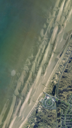
Sefton Coast: Ridges and Runnels
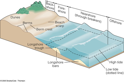
The beach profile extends from the offshore zone to the backshore zone. The beach itself forms from the nearshore to the backshore within the tidal range.within the tidal range At coasts dominated by destructive waves the beach profile is narrow and steep. The tidal range will also be smaller. At coasts dominated by constructives waves, large wide and flat beaches develop and the tidal range is more extensive. It is on these large relatively flat beaches that a greater number of depositional features occur. The smallest in scale, are beach drainage features, such as ridges and runnels. Ridges and runnels form in the foreshore zone. Ridges are areas of the foreshore that are raised above the adjacent shore which dips into a Runnel. The cross-section is similar to that of hills and valleys but at a much smaller scale. Ridge and runnel systems are formed due to the interaction of tides, currents, sediments and the beach topography. They will only form on shallow gradient beaches. They form as a simple drainage routes for incoming and outgoing tides. Water flows in and out via the runnel, creating a hollow channel. The ridges are the raised section next to the runnel. Other depositional features such as berms, which are raised ridges or plateaus that mark highest tidal point. It's normal for a beach profile to support several berms, that mark different tide levels. The highest berm is called the spring tide berm and is made up of the largest and most course sediment, which merges into the storm beach at the very back of the shore. A smaller feature of the beach profile are beach cusps. Beach cusps are shoreline features made up of various grades of sediment that form an arc pattern.
Cusps
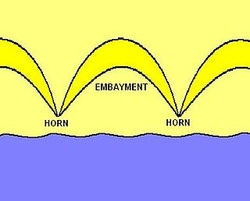
Cusps
Source: Wikapedia
The horns are made up of coarser materials and the embayment contains finer grain sediment. They are most noticeable on shorelines with coarser sediment such as pebble beaches, however, they can occur on beaches with sediment of any size. They nearly always occur in a regular pattern with cusps of equal size and spacing. Cusps are most often a few metres long, however they may reach 60m across. It's unclear how cusps form but once they do they are a self sustaining formation. This is because once an oncoming wave hits the horn of a beach cusp it is split and forced into two directions. The breaking of a wave into the cusps slows its velocity, causing coarser sediment to fall out of suspension and be deposited on the horns. The waves then flow along the embayments (picking up finer sediment) and run into one another in the middle. After this collision these waves attempt to flow back out to sea where they are met by incoming waves. Therefore, once the cusp is established, coarser sediment is constantly being deposited on the horn and finer sediment is being eroded away from the embayments. In this way a positive feedback occurs which should at leats maintain the cusp size if not increase theri size.
Offshore bars are elongated ridges and mounds of sand or gravel deposited beyond a shoreline by currents and waves. The term offshore bar has been used to describe both submerged bars, and emergent islands separated from a shoreline by a lagoon, features more correctly identified as barrier islands. Submerged bars are only exposed at low tide, if ever, while barrier islands remain at least partially exposed, even at high tide.
Longshore, tidal, and fluvial currents construct submerged bars in shallow water coastal environments. The amount of unconsolidated sediment available in a shore-zone system, called its sand budget, determines the number of bars and other depositional features that form along the coastline. A shore-zone system's dominant mode of sediment transport controls the shapes and orientations of its depositional forms, including the types of submerged bars. Some form as aresult of long currents that develop a trough and bar feature in the nearshore zone. In other cases, storms, with destrucutive waves with high breakers and strong backwash drag berm sediment offshore to help form longshore bars. These bars then migrate shoreward under calmer more constructuve wave patterns. This process also helps create the steep shore facing slopes of berms.
Text adapted from www. bookrags.com/research/offshore-bars
Drift Aligned Beaches
Longshore Drift and Longshore Currents
Drfit aligned beaches transfer sediment along the beach due to the angle of wave approaching the shoreline on an angle, under the influence of prevailing winds. As a consequence, large wide beaches struggle to establish. However, these beaches are associated with a range of depositional features that develop along the coast, including spits. The diagram to the right shows the process of longshore drift and longshore currents. Prevailing wind brings waves in on an angle,w hich is slightly reduced in the nearshore by wave refraction. As waves break, their swach transports sediment up the beach at angle but the backwash under the influence of gravity bring it back perpendicular. As a result sediment is transported down the beach in a zig-zag pattern. Most sediment is suspended in the water but when moved by the breaking wave it is transported through saltation and traction. A strong current is also present in the nearshore, called the longshore current. Sediment is also transported in the longshore current. The current varies in strength from beach to beach but works like stream down within trough between the beach and an offshore bar. This can be seen in the diagram below. It is these offshore currents that explain the all-too-common experience, when bathing at the seaside, you enter the sea at one point but when you come out you realise that you have drifted some distance down the beach. Many a time as a child this caused me great stress. I remember very clearly the feeling my parents had left me behind, when in fact I had drfited in the offshore current. At breaks within the offshore bar, surfers will be all-too-familiar with the powerful rip-currents that develop. This is illustrated in the diagram below and shown in the following animation.

Longshore Current in the nearshore
A a result of longshore drift and longshore currents sediment is trandsferred alomg the coast floowing the direction of the current. This leads to the development of features shown in the diagram below.
Features of a drift aligned depositional beaches
Depositional Features Associated with Drift Aligned Beaches
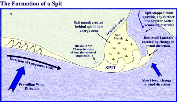
Diagram and text taken and adapted from South West Coastal Group.
Spits are long narrow ridges of sand and shingle which project from the coastline into the sea. The formation of a spit begins due to a change in the direction of the coastline, where a low energy zone is found. This can also be at the mouth of the estuary. The main source of material building up a spit is from long shore drift and current, which brings material from further down the coast.
Where there is a break in the coastline and a slight drop in energy, long shore drift will deposit material at a faster rate than it can be removed and gradually a ridge is built up, projecting outwards into the sea - this continues to grow by the process of long shore drift and the deposition of material. A change in prevailing wind direction often causes the end of spits to become hooked (also known as a recurved lateral). On the spit itself, sand dunes often form and salt-loving vegetation colonises. Water becomes trapped behind the spit, creating a low energy zone, as the water begins to stagnate, mud and marshland often begins to colonise behind the spit; spits may continue to grow until deposition can no longer occur, for example due to increased depth, or the spit begins to cross the mouth of a river and the water removes the material faster than it can deposited - preventing further build up. These marshland are called salt marshes Bars forms in a similar way to spits, as longshore drift transports sediment and shingle down the beach it deposits it low energy zones, such as bays. At a bay the bar, if continiued to be fed by sediment will extend across the bay cutting off a lagoon behind. In some area, bars extend to join the mainland to an island. This forms a sediment ridge called a tombolo; a good example is Llandudno in North Wales. Tombolos. Cuspate forelands can be described as triangular beaches. They form due to logshore drift meoveing sediment in opposing directions. The two sets of storm waves build up a series of ridges, each protecting the material behind it, creating the triangular feature. Cuspate forelands form due to the positioning of the coast and theirorientation to incoming tides and prevailing winds. A common exam question at Post 16 requires students to describe and explain coastal features. Students often explain well but description is often poorly done. The diagram below shows an annotated photograph of Dawlish Bay, in South Devon. It models sound description that examiners are looking for.
Where there is a break in the coastline and a slight drop in energy, long shore drift will deposit material at a faster rate than it can be removed and gradually a ridge is built up, projecting outwards into the sea - this continues to grow by the process of long shore drift and the deposition of material. A change in prevailing wind direction often causes the end of spits to become hooked (also known as a recurved lateral). On the spit itself, sand dunes often form and salt-loving vegetation colonises. Water becomes trapped behind the spit, creating a low energy zone, as the water begins to stagnate, mud and marshland often begins to colonise behind the spit; spits may continue to grow until deposition can no longer occur, for example due to increased depth, or the spit begins to cross the mouth of a river and the water removes the material faster than it can deposited - preventing further build up. These marshland are called salt marshes Bars forms in a similar way to spits, as longshore drift transports sediment and shingle down the beach it deposits it low energy zones, such as bays. At a bay the bar, if continiued to be fed by sediment will extend across the bay cutting off a lagoon behind. In some area, bars extend to join the mainland to an island. This forms a sediment ridge called a tombolo; a good example is Llandudno in North Wales. Tombolos. Cuspate forelands can be described as triangular beaches. They form due to logshore drift meoveing sediment in opposing directions. The two sets of storm waves build up a series of ridges, each protecting the material behind it, creating the triangular feature. Cuspate forelands form due to the positioning of the coast and theirorientation to incoming tides and prevailing winds. A common exam question at Post 16 requires students to describe and explain coastal features. Students often explain well but description is often poorly done. The diagram below shows an annotated photograph of Dawlish Bay, in South Devon. It models sound description that examiners are looking for.

Spit development is explained in the animation below and the video explains the value of saltmarshes.
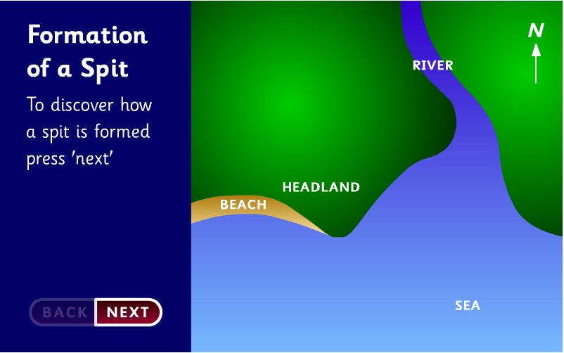
Spits Development Explained
|
Salt Marsh Video
|
Dune Formation and Evolution
Dunes form typically on large flat beach profiles with a large sediment supply to the backshore. Dunes develop in a different way to other depositional features because they are the result of the interaction between marine processes and the atmosphere. In brief, dunes begin to form beyond the strandline of the beach where dry sediment is transported by wind through saltation and suspension. Beach litter and debris that collects on the storm beach acts as an obstacle to saltation and sediment begins to build up. Over time, an embryo dune develops, which may become vegetated by marram grasses. Vegetation stabilizes the dunes in two ways. Firstly, the roots bind the sand together, and secondly the above ground vegetation traps particles of sand as they are blown over the surface. When dunes are less vegetated they remain unstable and so they migrate. This procees can be seen in the animation below:

Dune Migration Animation
Dunes have a typical form, the windward side is gentle sloping and shaped my wind movement. The leeward side faces away from the shore and is steeper and unstable. Dunes increase in size inland. As vegetation stabilizes the dunes, fore dunes and yellow dunes develop. Within dune profiles there is clear crest and trough pattern. The troughs are called slacks and result form a positive feedback of continued removal of sediment out of the trough with its transfer by wind up the winward side of the next dune. It is is common for the slack to be eroded so much that it reaches the water table where salt rich ponds are found. Biodiversity increases inland as more and more plants colonise the dune system. The climax community is the typical climax community of the climate. In the UK this is Oak, Beach and Birch tree varieties.There is a good description of dune formation and erosion at the Geography site here.
|
Sand Dune Ecosystems View more PowerPoint from jacksonthree |
|
